| Hatogaya 鳩ヶ谷市 | |
|---|---|
| Former municipality | |
 Hatogaya city hall Hatogaya city hall | |
 Flag Flag Emblem Emblem | |
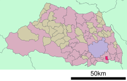
 Location of Hatogaya in Saitama Prefecture Location of Hatogaya in Saitama Prefecture | |
 | |
| Coordinates: 35°50′N 139°44′E / 35.833°N 139.733°E / 35.833; 139.733 | |
| Country | Japan |
| Region | Kantō |
| Prefecture | Saitama Prefecture |
| Merged | October 11, 2011 (now part of Kawaguchi) |
| Area | |
| • Total | 6.22 km (2.40 sq mi) |
| Population | |
| • Total | 61,781 |
| • Density | 9,900/km (26,000/sq mi) |
| Time zone | UTC+09:00 (JST) |
| Symbols | |
| Bird | Oriental turtle dove |
| Flower | Carnation |
| Tree | Osmanthus |
Hatogaya (鳩ヶ谷市, Hatogaya-shi) was a city located in Saitama Prefecture, Japan.
As of April 1, 2011, the city had an estimated population of 61,781, with 26,902 households, and a population density of 9,932.64 per km. The total area was 6.22 km, the second smallest among all cities in Japan.
The city was founded on March 1, 1967.
On October 11, 2011, Hatogaya was merged into the expanded city of Kawaguchi.
References
- ^ ミニ市2位、埼玉・鳩ケ谷消える 指定市狙い川口に編入 (in Japanese). Asahi Shimbun. October 11, 2011. Retrieved October 11, 2011.
External links
- Official website (in Japanese)
This Saitama Prefecture location article is a stub. You can help Misplaced Pages by expanding it. |