| Hazm Al Markhiya حزم المرخية | |
|---|---|
| District | |
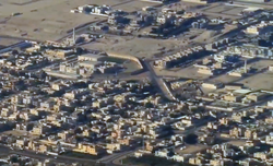
 Aerial view of the northeastern boundary of Hazm Al Markhiya Aerial view of the northeastern boundary of Hazm Al Markhiya | |
  | |
| Coordinates: 25°20′10″N 51°29′39″E / 25.33611°N 51.49417°E / 25.33611; 51.49417 | |
| Country | |
| Municipality | Ad-Dawhah |
| Zone | Zone 67 |
| District no. | 107 |
| Area | |
| • Total | 4.2 km (1.6 sq mi) |
| Population | |
| • Total | 8,967 |
| • Density | 2,100/km (5,500/sq mi) |
Hazm Al Markhiya (Arabic: حزم المرخية, romanized: Ḥazm al-Markhiyah) is a neighborhood of Doha, Qatar.
Etymology
In Arabic, "hazm" refers to a natural hill. The other constituent is a reference to the neighboring district of Al Markhiya, which received its name from a tree that grows abundantly in the region known locally as "markh" (Leptadenia pyrotechnica).
Landmarks
- Bin Muftah Medical Center on Al Markhiya Street.
- Feto Maternal Center on Rawdat Al Tair Street.
- West Bay Health Centre on Al Asdaf Street.
- Water Networks Affairs Laboratory on Saihan Street.
- Green Qatar Centre & Qatar Green Centre Park on Jery Al Hesan Street.
- Al Markhiya Complex on Saihan Street.
- Embassy Of The Republic Of Venezuela in Doha on Samura Bin Jundub Street.
- Embassy of The Central African Republic in Doha on Rawdat Nazwa Street.
Transport
Major roads that run through the district are University Street, Al Khafji Street and Al Markhiya Street.
Demographics
As of the 2010 census, the district comprised 900 housing units and 71 establishments. There were 8,586 people living in the district, of which 48% were male and 52% were female. Out of the 8,586 inhabitants, 67% were 20 years of age or older and 33% were under the age of 20. The literacy rate stood at 95.8%.
Employed persons made up 52% of the total population. Females accounted for 49% of the working population, while males accounted for 51% of the working population.
Education

The following schools are located in Hazm Al Markhiya:
| Name of School | Curriculum | Grade | Genders | Official Website | Ref |
|---|---|---|---|---|---|
| Kanga's Pouch Nursery | British | Kindergarten | Both | Official website | |
| Edison International Academy | British | Kindergarten – Primary | Both | Official website | |
| Tiny Town British Nursery | British | Kindergarten | Both | N/A | |
| The Community College of Qatar for Boys | Qatari | College | Male-only | Official website | |
| Al Bayan First Independent Elementary School for Girls | Qatari | Primary | Female-only | N/A |
References
- "District Area Map". Ministry of Development Planning and Statistics. Retrieved 1 March 2019.
- "2010 population census" (PDF). Qatar Statistics Authority. Archived from the original (PDF) on 2 April 2015. Retrieved 29 June 2015.
- "Qatar's opulent Al Hazm soft-opens to visitors". Doha News. 7 May 2017. Retrieved 20 January 2019.
- "District map". The Centre for Geographic Information Systems of Qatar. Archived from the original on 24 November 2020. Retrieved 7 January 2019.
- ^ "Qatar Landmarks". Ministry of Development Planning and Statistics. Retrieved 8 January 2019.
- "Index map of Qatar". ArcGIS.com. Retrieved 30 August 2019.
- "Housing units, by type of unit and zone (April 2010)" (PDF). Qatar Statistics Authority. Archived from the original (PDF) on 8 July 2015. Retrieved 7 August 2015.
- "Establishments by status of establishment and zone (April 2010)" (PDF). Qatar Statistics Authority. Archived from the original (PDF) on 8 July 2015. Retrieved 7 August 2015.
- ^ "Geo Statistics Application". Ministry of Development Planning and Statistics. Archived from the original on 11 September 2012. Retrieved 7 August 2015.
- "Kanga's Pouch Nursery". Doha Mums. Retrieved 8 January 2019.
- "Edison International Academy - Dahl Alhamam 2". Ministry of Education and Higher Education (Qatar). Retrieved 8 January 2019.
- "Tiny Town British Nursery". schoolsinqatar.net. Retrieved 8 January 2019.
This Qatari location article is a stub. You can help Misplaced Pages by expanding it. |