| Heeswijk | |
|---|---|
| Village | |
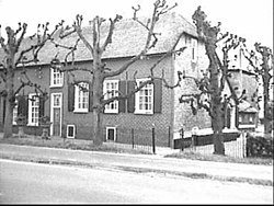
 Farm in Heeswijk Farm in Heeswijk | |
 | |
| Coordinates: 52°03′06″N 4°58′04″E / 52.05167°N 4.96778°E / 52.05167; 4.96778 | |
| Country | Netherlands |
| Province | Utrecht |
| Municipality | Montfoort |
| Area | |
| • Total | 3.45 km (1.33 sq mi) |
| Elevation | 1 m (3 ft) |
| Population | |
| • Total | 690 |
| • Density | 200/km (520/sq mi) |
| Time zone | UTC+1 (CET) |
| • Summer (DST) | UTC+2 (CEST) |
| Postal code | 3417 |
| Dialing code | 0348 |
Heeswijk is a village in the central Netherlands. It is located in Montfoort, Utrecht, about 6 km northwest of IJsselstein.
The village is first mentioned in 1204 as Hesewic, and means "settlement near shrubbery". The postal authorities have placed it under Montfoort, and it has no place name signs. It used to have a parish church, but the church was moved to neighbouring Montfoort. In 1840, Heeswijk was home to 59 people.
References
- ^ "Kerncijfers wijken en buurten 2021". Central Bureau of Statistics. Retrieved 27 March 2022.
- "Postcodetool for 3417AA". Actueel Hoogtebestand Nederland (in Dutch). Het Waterschapshuis. Retrieved 27 March 2022.
- "Heeswijk - (geografische naam)". Etymologiebank (in Dutch). Retrieved 28 March 2022.
- "Postcode 3417 in Montfoort". Postcode bij adres (in Dutch). Retrieved 28 March 2022.
- "Heeswijk (Montfoort)". Plaatsengids (in Dutch). Retrieved 28 March 2022.
| Populated places in the municipality of Montfoort | |
|---|---|
| Towns | |
| Villages | |
| Hamlets | |
| List of cities, towns and villages in Utrecht | |
This Utrecht location article is a stub. You can help Misplaced Pages by expanding it. |