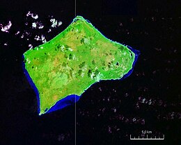
 Satellite image of Little Inagua, Bahamas Satellite image of Little Inagua, Bahamas | |
 | |
| Geography | |
|---|---|
| Location | Atlantic Ocean |
| Coordinates | 21°30′N 73°00′W / 21.500°N 73.000°W / 21.500; -73.000 |
| Archipelago | Lucayan Archipelago |
| Area | 50 sq mi (130 km) |
| Administration | |
| Bahamas | |
| Demographics | |
| Population | 0 |
| Additional information | |
| Time zone | |
| • Summer (DST) | |
| ISO code | BS-IN |
Little Inagua is a small remote island in the Bahamas. It is the largest uninhabited island in the Caribbean and has no fresh water. The island remains in an undisturbed and natural state.
In 2002, the Bahamas Government designated it as Little Inagua National Park. The park is approximately 31,600 acres and its designation extends into the marine area to 100 fathoms. The park holds a wide variety of reptiles, birds, wild goats, and donkeys. Additionally, the island is a nesting location for a critically endangered sea turtle species.
On July 27, 2017, the U.S. Coast Guard and the Royal Bahamas Defence Force rescued six Haitian migrants from the island.
See also
References
- ^ "Little Inagua National Park". The Bahamas National Trust. Retrieved 15 August 2023.
- "Unprecedented Expansion of National Park System" (PDF). Currents. Bahamas National Trust. June 2002. p. 4. Retrieved 4 January 2019.
- "LITTLE INAGUA NATIONAL PARK". The Islands of the Bahamas. Bahamas Ministry of Tourism. Retrieved 15 August 2023.
- "Things to Do in Great Inagua". Frommer. Retrieved 15 August 2023.
- "Coast Guard, Royal Bahamas Defence Force rescues 6 Haitian migrants off Little Inagua". Coast Guard News. 29 July 2017. Retrieved 15 August 2023.
This Bahamian location article is a stub. You can help Misplaced Pages by expanding it. |