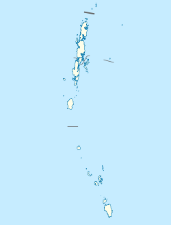
Village in Andaman and Nicobar Islands, India
| Henhoaha | |
|---|---|
| village | |
  | |
| Coordinates: 6°46′50″N 93°49′33″E / 6.780621°N 93.8258513°E / 6.780621; 93.8258513 | |
| Country | India |
| State | Andaman and Nicobar Islands |
| District | Nicobar |
| Tehsil | Great Nicobar |
| Elevation | 47 m (154 ft) |
| Population | |
| • Total | 0 |
| Time zone | UTC+5:30 (IST) |
| 2011 census code | 645188 |
Henhoaha is a village in the Nicobar district of Andaman and Nicobar Islands, India. It is located on the island of Great Nicobar, near Indira Point, the southernmost point of India.
Administration
The village comes under the administration of Laxmi Nagar panchayat.
Demographics
The village lost a number of its residents in the 2004 tsunami. According to the 2011 census of India, Henhoaha (or In-Hig-Loi) does not have any households and is uninhabited.
| Total | Male | Female | |
|---|---|---|---|
| Population | 0 | 0 | 0 |
References
- Henhoaha on Maplandia Accessed 28 December 2013.
- National Geographic Atlas of the World. National Geographic. 2005.
- List of Villages Archived 5 March 2016 at the Wayback Machine, Integrated Management Information System (IMIS), Ministry of Drinking Water and Sanitation.
- ^ "District Census Handbook - Andaman & Nicobar Islands" (PDF). 2011 Census of India. Directorate of Census Operations, Andaman & Nicobar Islands. Archived from the original (PDF) on 1 August 2015. Retrieved 21 July 2015.