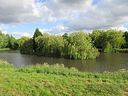
| Highfields Lake | |
|---|---|
 Islands in Highfield Lake Islands in Highfield Lake | |
 | |
| Location | South Yorkshire, England |
| Coordinates | 53°33′27″N 1°11′4″W / 53.55750°N 1.18444°W / 53.55750; -1.18444 |
| Basin countries | United Kingdom |
Highfields Lake is an ornamental lake in the Woodlands wildlife park at Highfields, north of Doncaster, South Yorkshire, England.
It is filled by the Pick Burn, which then flows on to join the River Don as Bentley Mill Stream. The lake was originally built by the owners of Woodlands, a country house that lent its name to the model village built for the miners of Brodsworth Colliery.
The lake now forms part of High Country Park and Woodlands wildlife park, run by Doncaster Metropolitan Borough Council, whilst Woodlands is now a social club. Doncaster Greenway North passes to the north of the lake alongside the A638 road.
References
- "Highfields Country Park - Doncaster Council". www.doncaster.gov.uk. Retrieved 19 November 2018.
- "Bentley Mill Stream". environment.data.gov.uk. Retrieved 19 November 2018.
- Goodchild, John (2001). South Yorkshire collieries. Stroud: Tempus. p. 126. ISBN 0752421484.
- Bateman, Stephanie (12 June 2015). "Highfield Country Park holds volunteer days". South Yorkshire Times. Retrieved 19 November 2018.
- "Doncaster Greenway North - Map". sustrans.org.uk. Retrieved 19 November 2018.
| Lakes in Yorkshire | ||
|---|---|---|
| East Riding of Yorkshire |  | |
| North Yorkshire | ||
| South Yorkshire | ||
| West Yorkshire | ||
| Related articles | ||
| Notes |
| |