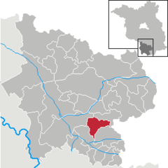
Municipality in Brandenburg, Germany
Hohenleipisch (Sorbian : Lubuš ) is a municipality in the Elbe-Elster district, in Brandenburg , Germany .
History
Two kilometres west of Hohenleipisch is an old brown coal and quartz sand pit called Grube Gotthold .
From 1952 to 1990, Hohenleipisch was part of the Bezirk Cottbus of East Germany .
Demography
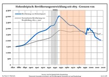
Development of Population since 1875 within the Current Boundaries (Blue Line: Population; Dotted Line: Comparison to Population Development of Brandenburg state; Grey Background: Time of Nazi rule; Red Background: Time of Communist rule)
Hohenleipisch:
Year
Population
1875
1 500
1890
1 700
1910
2 587
1925
2 888
1933
3 209
1939
3 321
1946
4 016
1950
3 937
1964
3 297
1971
3 252
Year
Population
1981
2 850
1985
2 759
1989
2 626
1990
2 608
1991
2 566
1992
2 516
1993
2 845
1994
3 024
1995
2 836
1996
3 001
Year
Population
1997
3 008
1998
3 022
1999
2 896
2000
2 822
2001
2 845
2002
2 803
2003
2 679
2004
2 660
2005
2 552
2006
2 383
Year
Population
2007
2 304
2008
2 258
2009
2 235
2010
2 171
2011
2 188
2012
2 148
2013
2 089
2014
2 069
2015
2 048
2016
2 056
References
Landkreis Elbe-Elster Wahl der Bürgermeisterin / des Bürgermeisters . Retrieved 27 June 2024.
"Bevölkerungsentwicklung und Bevölkerungsstandim Land Brandenburg Dezember 2022" (PDF). Amt für Statistik Berlin-Brandenburg Population Projection Brandenburg at Wikimedia Commons
Towns and municipalities in Elbe-Elster
Coat of Arms of Elbe-Elster district
Categories :
Text is available under the Creative Commons Attribution-ShareAlike License. Additional terms may apply.
**DISCLAIMER** We are not affiliated with Wikipedia, and Cloudflare.
The information presented on this site is for general informational purposes only and does not constitute medical advice.
You should always have a personal consultation with a healthcare professional before making changes to your diet, medication, or exercise routine.
AI helps with the correspondence in our chat.
We participate in an affiliate program. If you buy something through a link, we may earn a commission 💕
↑
 Coat of arms


