| Hoklabari होक्लाबारी | |
|---|---|
| Village development committee | |
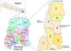
 Kanepokhari in Morang District. Kanepokhari in Morang District.Hoklabari VDC became Ward 1 | |
| Coordinates: 26°33′N 87°28′E / 26.55°N 87.47°E / 26.55; 87.47 | |
| Country | |
| Zone | Koshi Zone |
| District | Morang District |
| Population | |
| • Total | 4,520 |
| Time zone | UTC+5:45 (Nepal Time) |
Hoklabari (Nepali: होक्लावारी) was a village development committee in Morang District in the Koshi Zone of south-eastern Nepal. In 2017 it was absorbed by the newly created Kanepokhari Rural Municipality.
Location
Hoklabari was in Nepal, Eastern Region, Kosī Zone, Morang. Its elevation is about 90 metres (300 ft) above sea level. The Köppen climate classification is Cwa : Monsoon-influenced humid subtropical climate.
Population
Majority ethnic groups are Chettri and Brahmins alongside Santal and others. This village is famous for production of mustard and is also a major cultivator of rice and wheat.
At the time of the 1991 Nepal census it had a population of 4,520 people living in 806 individual households. The table below shows the populations in 2011 of the wards of Kanepokhari Rural Municipality. Hoklabari became Ward 1 when Kanepokhari was constituted in March 2017.
| Ward | Ward Kendra | Households | 2011 Population | Male | Female | Formed from |
|---|---|---|---|---|---|---|
| 1 | VDC Building Bayarban | 1121 | 4830 | 2281 | 2549 | Hoklabari all wards |
| 2 | VDC Building | 1368 | 5941 | 2758 | 3183 | Keroun Wards 3, 4, 6-9 |
| 3 | Jayanepal Chowk | 1174 | 5232 | 2449 | 2783 | Bayarban Wards 1-5 |
| 4 | Bayarban Bajar | 1174 | 5242 | 2363 | 2879 | Bayarban Wards 6, 7 |
| 5 | Bhousabari | 1558 | 6776 | 3107 | 3669 | Keroun Wards 1, 2, 5 |
| 6 | VDC Building | 1340 | 5771 | 2613 | 3158 | Bayarban Ward 8 |
| 7 | Aitabare Bajar | 948 | 4241 | 1916 | 2325 | Bayarban Ward 9 |
References
- "Hoklabari", GeoNames, retrieved 2020-06-14
- "Hoklabari, Morang, Kosī Zone, Purwanchal, Nepal", Mindat, retrieved 2020-06-14
- "Nepal Census 2001". Nepal's Village Development Committees. Digital Himalaya. Archived from the original on 12 October 2008. Retrieved 18 December 2008.
- Unit-9: Kanepokhari Gaunpalika (PDF), District Coordination Committee Office : Morang, Nepal, p. 10, retrieved 2020-06-10
| Morang District | ||
|---|---|---|
| Headquarter: Biratnagar | ||
| Metropolitan City |  | |
| Municipalities | ||
| Rural Municipalities | ||
This article about a location in Morang District, Nepal is a stub. You can help Misplaced Pages by expanding it. |