| Honguedo Strait | |
|---|---|
| Détroit de Honguedo | |
 Gulf of St. Lawrence, Gaspé, Saint-Maurice-de-l'Échouerie village, municipal stop of the Old Factory Gulf of St. Lawrence, Gaspé, Saint-Maurice-de-l'Échouerie village, municipal stop of the Old Factory | |
| Location | Gulf of St. Lawrence |
| Coordinates | 49° 33' 41" N 63° 59' 45" W |
| Basin countries | Quebec, Canada |
The Honguedo Strait (French: Détroit d'Honguedo), the toponym designates the wide passage of the Gulf of St. Lawrence between the Gaspésie peninsula and Anticosti Island, Quebec, Canada.
Toponymy
The name Honguedo first appeared in the reports of Jacques Cartier of 1535–1536. In the 16th century, it was known as the Saint-Pierre Strait, especially on maps by Gerardus Mercator (1569) and Cornelius Wytfliet (1597).
Only by the 20th century, Honguedo came into use, and in 1934, the Geographic Board of Quebec officially adopted it to commemorate the 400th anniversary of Jacques Cartier's arrival in North America. Yet, the origin of the name is uncertain; it may derive from the Mi'kmaq word for "gathering place", or from the Iroquois word hehonguesto, meaning "one's own nose".
- About Honguedo Strait
-
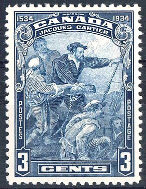
 Jacques Cartier (circa 1491-1557), Canada Post 3 cents stamp 1934, designed by George Arthur Gundersen (1910-1975)
-
 Gulf of St. Lawrence, Gaspé, Saint-Maurice-de-l'Échouerie village, municipal stop of the Old Factory
Western Honguedo Strait Coral Conservation Area
With an area of 496 km2, the Western Honguedo Strait Coral Conservation Area is home to species of corals and sea pens that create structures that provide a diverse habitat for many marine species.
- Pennatula aculeata Danielssen, 1860. — Plume de mer. — (Sea Pen).
- Pennatula grandis Ehrenberg, 1834. — Grande Pennatule. — (Greater sea pen). — Större fjäderpenna (Suédois).
- Anthoptilum grandiflorum (Verrill, 1879). — Pennatule à grandes fleurs. — (Large-flowered pennatula).
References
- ^ "Saint-Maurice-de-l'Échouerie (Gaspé)". Gouvernement of Quebec (in French). Commission de Toponymy Quebec. 17 January 1985. Retrieved 23 September 2024.
In Gaspésie, the Magdalen Islands and the North Shore, a haul-out site is a place where seals have taken to coming to rest.
- "Honguedo Strait and South Shore of the St. Lawrence River" (PDF). Fischeries and Oceans Canada (in French). Canadian Hydrographic Service. 13 October 2022. pp. 60 of 90. Retrieved 22 September 2024.
Canadian Nautical Instructions: St. Lawrence River, Cape Whittle/Cap Gaspé in Les Escoumins and Anticosti Island
- ^ "Honguedo Strait, toponymy". Gouvernement of Quebec (in French). Commission de Toponymy Quebec. 5 December 1968. Retrieved 22 September 2024.
The Commission de géographie du Québec, now the Commission de toponymie, adopted this toponym in 1934 to commemorate the 400th anniversary of the arrival of Jacques Cartier in New France.
- "George Arthur Gundersen". Numisma. Retrieved 6 September 2024.
His first Canadian stamp design (Jacques Cartier) was issued in 1934 and last (UPU Centenary) in 1974. Works of the artist
- "The Explorers Jacques Cartier 1534-1542". Canadian Museum of History. Retrieved 6 September 2024.
Jacques Cartier was a sufficiently experienced navigator to be asked by Francis I to undertake the official exploration of North America. There is no doubt that he was already familiar with the sea route that he took in 1534
- "Western Honguedo Strait Coral Conservation Area". Gouvernement of Canada. Fisheries and Oceans Canada. 9 September 2019. Retrieved 23 September 2024.
High concentrations of these soft corals create habitat with complex structures that provide refuge, feeding, and rearing areas for many marine species, thus supporting greater biodiversity.
- "Cold Water Corals and Sponges". Gouvernement of Canada. Fisheries and Oceans Canada. 2012.
They provide the complex habitat structure that is important to invertebrates, fish and other deep sea life. High-complexity sponge reefs are associated with a greater abundance and diversity of species.
- GBIF. "Pennatula aculeata Danielssen, 1860". Global Biodiversity Information Facility (GBIF). Retrieved 23 September 2024.
International network and data infrastructure funded by world governments with the goal of providing everyone, everywhere, with free access to data on all forms of life on Earth.
- GBIF. "Pennatula grandis Ehrenberg, 1834". Global Biodiversity Information Facility (GBIF). Retrieved 23 September 2024.
international network and data infrastructure funded by world governments with the goal of providing everyone, everywhere, with free access to data on all forms of life on Earth.
- GBIF. "Anthoptilum grandiflorum (Verrill, 1879)". Global Biodiversity Information Facility (GBIF). Retrieved 23 September 2024.
International network and data infrastructure funded by world governments with the goal of providing everyone, everywhere, with free access to data on all forms of life on Earth
External links
- Atlas of Sponges from the Estuary and Northern Gulf of St. Lawrence Multidisciplinary Trawl Survey, Fisheries and Oceans Canada 2006-2017, PP 59
49°15′N 64°00′W / 49.250°N 64.000°W / 49.250; -64.000
This Quebec location article is a stub. You can help Misplaced Pages by expanding it. |