| This article needs additional citations for verification. Please help improve this article by adding citations to reliable sources. Unsourced material may be challenged and removed. Find sources: "Hopetown" – news · newspapers · books · scholar · JSTOR (November 2007) (Learn how and when to remove this message) |
Place in Northern Cape, South Africa
| Hopetown | |
|---|---|
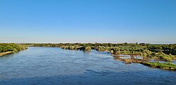
 The Orange River on the outskirts of town The Orange River on the outskirts of town | |
  | |
| Coordinates: 29°37′33″S 24°05′08″E / 29.62583°S 24.08556°E / -29.62583; 24.08556 | |
| Country | South Africa |
| Province | Northern Cape |
| District | Pixley ka Seme |
| Municipality | Thembelihle |
| Area | |
| • Total | 73.86 km (28.52 sq mi) |
| Population | |
| • Total | 10,259 |
| • Density | 140/km (360/sq mi) |
| Racial makeup (2011) | |
| • Black African | 18.8% |
| • Coloured | 73.1% |
| • Indian/Asian | 0.7% |
| • White | 6.9% |
| • Other | 0.5% |
| First languages (2011) | |
| • Afrikaans | 88.1% |
| • Xhosa | 7.2% |
| • Tswana | 1.5% |
| • English | 1.3% |
| • Other | 2.0% |
| Time zone | UTC+2 (SAST) |
| Postal code (street) | 8750 |
| PO box | 8750 |
| Area code | 053 |
Hopetown is a town which lies at the edge of the Great Karoo in South Africa's Northern Cape province. It is situated on an arid slope leading down to the Orange River. The first diamond discovered in South Africa, the Eureka Diamond, was found at Hopetown.
History
Hopetown was founded in 1850 when Sir Harry Smith extended the northern frontier of the Cape Colony to the Orange River. A handful of settlers claimed ground where there was a natural ford over the Orange River, and by 1854 a frontier town had developed. Hopetown was named after William Hope, Auditor-General and Secretary of the Cape Colony Government at the time, and is often mistaken for a town in the Free State, South Africa, called Hoopstad.
Hopetown was a quiet farming area until several large diamonds, most notable the Eureka Diamond and the Star of South Africa, were discovered there between 1867 and 1869. The Cape Government Railways were founded in 1872, and the Cape government decided to run the main western line, between the Kimberley diamond fields and Cape Town on the coast, directly through Hopetown. The ford was upgraded to a railway bridge in 1884.
References
- ^ "Main Place Hopetown". Census 2011.
- Williams, Gardner Fred (1904). The diamond mines of South Africa. New York, B. F. Buck & company. p. 115. Retrieved 25 July 2009.
- Roberts, Brian (1976). Kimberley: turbulent city. New Africa Books. p. 13. ISBN 978-0-949968-62-3.
- Burman, Jose (1984). Early Railways at the Cape. Cape Town. Human & Rousseau, p.92. ISBN 0-7981-1760-5
| Places adjacent to Hopetown | ||||||||||||||||
|---|---|---|---|---|---|---|---|---|---|---|---|---|---|---|---|---|
| ||||||||||||||||
| Municipalities and communities of Pixley ka Seme District Municipality, Northern Cape | ||
|---|---|---|
| District seat: De Aar | ||
| Emthanjeni |  | |
| Kareeberg | ||
| Renosterberg | ||
| Siyancuma | ||
| Siyathemba | ||
| Thembelihle | ||
| Ubuntu | ||
| Umsobomvu | ||
This Northern Cape location article is a stub. You can help Misplaced Pages by expanding it. |