| Hortsavinyà | |
|---|---|
| Village | |
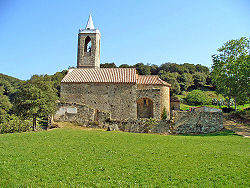
 Church of Santa Eulàlia (or Sant Llop) in Hortsavinyà Church of Santa Eulàlia (or Sant Llop) in Hortsavinyà | |
   | |
| Coordinates: 41°40′04″N 2°37′43″E / 41.66778°N 2.62861°E / 41.66778; 2.62861 | |
| Country | Spain |
| Autonomous community | Catalonia |
| Province | Barcelona |
| Comarca | Maresme |
| Municipality | Tordera |
| Elevation | 490 m (1,610 ft) |
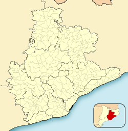
Hortsavinyà is a village within the municipality of Tordera in the comarca of Maresme, province of Barcelona, Catalonia, Spain.
The GR 92 long distance footpath, which roughly follows the length of the Mediterranean coast of Spain, has a staging point at Hortsavinyà. Stage 13 links northwards to Tordera, a distance of 12.8 kilometres (8.0 mi), whilst stage 14 links southwards to Vallgorguina, a distance of 17.4 kilometres (10.8 mi).
References
- Vissir3 (Map). Institut Cartogràfic i Geològic de Catalunya. Retrieved 18 November 2022.
- "GR 92: Sender de la Mediterrània" [GR 92: Mediterranean Path]. www.catalunya.com (in Catalan). Archived from the original on 7 November 2022. Retrieved 7 November 2022.
This article about a location in Catalonia is a stub. You can help Misplaced Pages by expanding it. |