| Igrane | |
|---|---|
| Town | |
 Igrane Igrane | |
 Coat of arms Coat of arms | |
 | |
| Coordinates: 43°11′42″N 17°08′20″E / 43.195°N 17.139°E / 43.195; 17.139 | |
| Country | |
| County | Split-Dalmatia |
| Area | |
| • Total | 3.1 km (1.2 sq mi) |
| Population | |
| • Total | 347 |
| • Density | 110/km (290/sq mi) |
| Time zone | UTC+1 (CET) |
| • Summer (DST) | UTC+2 (CEST) |
| Postal code | 21392 |
| Area code | 02 |

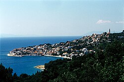
Igrane is a town in Croatia, around 19 km south from Makarska. It has about 420 inhabitants.
At the highest point of the village is the "Kula Zale" tower - named after Ivan Anticic, and built during the 17th century as a protection against Turks. The Pre-Romanesque church of St. Michael (Sveti Mihovil), dating from the 11th century, dominates the village.
Tourism and agriculture are the main sources of income for the inhabitants.
References
- Register of spatial units of the State Geodetic Administration of the Republic of Croatia. Wikidata Q119585703.
- "Population by Age and Sex, by Settlements" (xlsx). Census of Population, Households and Dwellings in 2021. Zagreb: Croatian Bureau of Statistics. 2022.
- "Population by presence in settlement". Census 2001. Croatian Bureau of Statistics. Retrieved 2011-01-18.
43°12′N 17°08′E / 43.200°N 17.133°E / 43.200; 17.133
This Split-Dalmatia County geography article is a stub. You can help Misplaced Pages by expanding it. |