For other uses, see IHME (disambiguation).
| Ihme | |
|---|---|
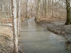
 The Ihme near the southern city boundary of Hanover The Ihme near the southern city boundary of Hanover | |
| Location | |
| Country | Germany |
| State | Lower Saxony |
| Location | Hanover Region |
| Physical characteristics | |
| Source | |
| • location | Near Wennigsen |
| • elevation | 70 m above sea level (NN) |
| Mouth | |
| • location | In Hanover into the Leine |
| • coordinates | 52°22′38″N 9°42′45″E / 52.3771°N 9.71245°E / 52.3771; 9.71245 |
| • elevation | 50 m above sea level (NN) |
| Length | 26.2 km (16.3 mi) |
| Basin size | 111 km (43 sq mi) |
| Basin features | |
| Progression | Leine→ Aller→ Weser→ North Sea |
| Landmarks |
|
| Population | 500,000 |
| Tributaries | |
| • left | Hirtenbach, Schneller Graben |
| • right | Seniebach |
| Navigable | Schneller Graben to Leine |
The Ihme (Wennigser Mühlbach in its upper course) is a river of Lower Saxony, Germany. It is a left tributary of the Leine.
The Ihme is 26 kilometres (16 mi) long. Its source is in the village Evestorf, a district of Wennigsen. After about 6 kilometres (4 mi), the Ihme reaches the city of Hanover, where it flows into the Leine. In order to protect the city centre of Hanover from flooding, much of the water of the Leine is rerouted by a ditch into the Ihme. A bridge over the Ihme is named in memory of Benno Ohnesorg.
-
 The confluence of the Ihme with the Leine, with the Leine shown on the right
-
 Ihme in a flood ditch to the left of a flooded bicycle path in Hanover, taking floodwater to the Leine.
The Ihme gives its name to the village Ihme that, together with the village Roloven, forms the Ronnenberg district of Ihme-Roloven.
See also
References
- ^ Environmental map service of Lower Saxony (Umweltkartendienst des Niedersächsischen Ministeriums für Umwelt, Energie und Klimaschutz)
This article related to a river in Lower Saxony is a stub. You can help Misplaced Pages by expanding it. |