| This article needs additional citations for verification. Please help improve this article by adding citations to reliable sources. Unsourced material may be challenged and removed. Find sources: "Ille" – news · newspapers · books · scholar · JSTOR (May 2020) (Learn how and when to remove this message) |
| Ille | |
|---|---|
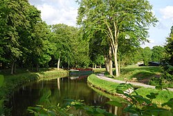
 The Ille in Chevaigné near Rennes The Ille in Chevaigné near Rennes | |
  | |
| Location | |
| Country | France |
| Physical characteristics | |
| Source | |
| • location | Near Dingé, Ille-et-Vilaine |
| Mouth | |
| • location | Vilaine |
| • coordinates | 48°6′27″N 1°41′50″W / 48.10750°N 1.69722°W / 48.10750; -1.69722 |
| Length | 48.9 km (30.4 mi) |
| Basin features | |
| Progression | Vilaine→ Atlantic Ocean |
The Ille (French pronunciation: [il] ; Breton: Il) is a small river in Brittany, France, right tributary of the river Vilaine. It is 48.9 km (30.4 mi) long. It flows into the Vilaine in the city Rennes.
The Ille is linked to the semi-tidal Rance river by the Canal d'Ille-et-Rance. By this canal, Rennes has a connection with the English Channel coast at St. Malo. The canal is used primarily for tourist boats.
The Ille flows through the department Ille-et-Vilaine and the following towns: Montreuil-sur-Ille, Betton and Rennes. From Montreuil to Rennes the river runs parallel to the Canal d'Ille-et-Rance.
References
This Brittany geographical article is a stub. You can help Misplaced Pages by expanding it. |
This article related to a river in France is a stub. You can help Misplaced Pages by expanding it. |