| Ilm | |
|---|---|
 River Ilm in Geisenfeld River Ilm in Geisenfeld | |
 | |
| Location | |
| Country | Germany |
| Physical characteristics | |
| Source | |
| • location | Upper Bavaria |
| Mouth | |
| • location | Abens |
| • coordinates | 48°49′43″N 11°45′36″E / 48.82861°N 11.76000°E / 48.82861; 11.76000 |
| Length | 83.8 km (52.1 mi) |
| Basin size | 579 km (224 sq mi) |
| Basin features | |
| Progression | Abens→ Danube→ Black Sea |
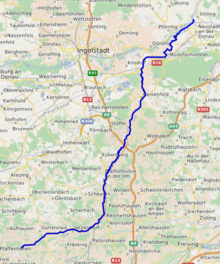
The Ilm is a river in Bavaria, Germany, left tributary of the Abens. Its source is near Altomünster. It is approx. 84 km long. It flows generally north through the small towns Hilgertshausen-Tandern, Reichertshausen, Pfaffenhofen an der Ilm, Geisenfeld and Vohburg. It flows into the Abens near Neustadt an der Donau.
References
- ^ Complete table of the Bavarian Waterbody Register by the Bavarian State Office for the Environment (xls, 10.3 MB)
This article related to a river in Bavaria is a stub. You can help Misplaced Pages by expanding it. |