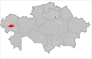
| Inder | |
|---|---|
| District | |
| Индер ауданы | |
 | |
| Coordinates: 48°18′36″N 51°26′24″E / 48.31000°N 51.44000°E / 48.31000; 51.44000 | |
| Country | Kazakhstan |
| Region | Atyrau Region |
| Administrative center | Inderbor |
| Government | |
| • Akim | Shamuratov Daryn Dyusembayevich |
| Area | |
| • Total | 4,200 sq mi (10,900 km) |
| Population | |
| • Total | 31,644 |
| Time zone | UTC+5 (West) |
Inder District (Kazakh: Индер ауданы, Inder audany) is a district of Atyrau Region in Kazakhstan. The administrative center of the district is the urban-type settlement of Inderbor. Population: 31,644 (2013 estimate); 30,582 (2009 Census results); 29,032 (1999 Census results).
Geography
Inder District lies in the Caspian Depression. The Ural river and its distributary Bagyrlai flow across the territory. Inder lake is located to the east of the Ural.
References
- "INDERSKY DISTRICT HAS A NEW AKIM". atpress.kz. 2022-09-14.
- ^ "Население Республики Казахстан" (in Russian). Департамент социальной и демографической статистики. Retrieved 27 December 2013.
- "www.geonames.de Subdivisions of Kazakhstan in local languages". Archived from the original on 2016-03-03. Retrieved 2008-04-21.
- ^ "Население Республики Казахстан" [Population of the Republic of Kazakhstan] (in Russian). Департамент социальной и демографической статистики. Retrieved 8 December 2013.
- "M-39 Topographic Chart (in Russian)". Retrieved 2 March 2023.
- Google Earth
This Kazakhstan location article is a stub. You can help Misplaced Pages by expanding it. |
