| Inkachaka Dam | |
|---|---|
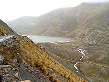
 Inkachaka Lake is situated along route 3 (on the left) which connects La Paz with Coroico Inkachaka Lake is situated along route 3 (on the left) which connects La Paz with Coroico | |
  | |
| Location | Bolivia La Paz Department |
| Coordinates | 16°23′55″S 68°02′30″W / 16.39861°S 68.04167°W / -16.39861; -68.04167 |
| Opening date | 1990 |
Inkachaka Dam (Aymara and Quechua, inka Inca, chaka bridge, "Inca bridge") is a dam in Bolivia situated in the La Paz Department, Pedro Domingo Murillo Province, La Paz Municipality, north east of La Paz.
See also
References
- katari.org Archived 2017-10-07 at the Wayback Machine Aymara-Spanish dictionary: Chaka (s.) - Puente.
- Teofilo Laime Ajacopa, Diccionario Bilingüe, Iskay simipi yuyayk'ancha, Quechua – Castellano, Castellano – Quechua, La Paz 2007 (Quechua-Spanish dictionary): inka. s. Soberano, monarca, supremo jerarca del Tawantinsuyu. chaka. - s. Puente. Construcción para pasar sobre ríos o fosos.
- summitpost.org Map of the area (north is upper left) showing "Laguna Inkachaka" (on the right)
- grande.civil.tohoku.ac.jp Dr. Eng. Andrés Calizaya Terceros, "Water supply system of La Paz and El Alto cities, Bolivia", 2009, containing basic information about the dams of the area
External links
- desastres.unanleon.edu.ni Basic information about the dams around La Paz
This La Paz Department geography article is a stub. You can help Misplaced Pages by expanding it. |