Human settlement in Scotland
Invergarry
| |
|---|---|
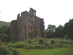
 Invergarry Castle Invergarry Castle | |
 | |
| Population | 438 |
| OS grid reference | NH302010 |
| Council area | |
| Country | Scotland |
| Sovereign state | United Kingdom |
| Post town | Invergarry |
| Postcode district | PH35 4 |
| Police | Scotland |
| Fire | Scottish |
| Ambulance | Scottish |
| UK Parliament | |
| Scottish Parliament | |
| 57°04′08″N 4°48′03″W / 57.06892°N 4.80086°W / 57.06892; -4.80086 | |

Invergarry (Scottish Gaelic: Inbhir Garadh) is a village in the Highlands of Scotland, located about 25 miles (40 km) north-east of Fort William. It is in the Great Glen, near where the River Garry flows into Loch Oich.
Geography
Near the centre of the village is the junction between the A82 road (from Inverness to Fort William) and the A87 road which branches off to the west towards Skye. The ruined Invergarry Castle is situated near the village on Creagan an Fhithich (the Raven's Rock), overlooking Loch Oich. As well as playing host to the local shinty club, Glengarry Shinty Club, it is the home town of shinty player, James Clark.
Invergarry Church (Church of Scotland) is situated on the hillside above the A87 road. The village has a primary school with a roll of 33.
See also
References
- "Invergarry". The Gazetteer for Scotland. School of GeoSciences, University of Edinburgh and The Royal Scottish Geographical Society. Retrieved 17 June 2018.
- Great Glen Churches, Our Churches, accessed on 30 August 2024