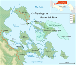
| Native name: Isla Popa | |
|---|---|
 Bocas del Toro Archipelago Bocas del Toro Archipelago | |
| Geography | |
| Coordinates | 9°9′N 82°7′W / 9.150°N 82.117°W / 9.150; -82.117 |
| Archipelago | Bocas del Toro Archipelago |
| Area | 53 km (20 sq mi) |
| Highest elevation | 0 m (0 ft) |
| Administration | |
| Panama | |
| Province | Bocas del Toro |
| District | Bocas del Toro |
Popa Island (in Spanish: Isla Popa) is the second largest island in the Bocas del Toro Archipelago, Panama, with 53 square kilometres (20 square miles).
Environment
The island is part of the Bocas del Toro Important Bird Area (IBA), designated as such by BirdLife International because it supports significant populations of white-crowned pigeons and three-wattled bellbirds.
See also
References
- St. Louis, Regis & Scott Doggett (2004), Lonely Planet Panama, Lonely Planet Publications, p. 227, ISBN 1-74104-133-3
- "Bocas del Toro Archipelago". BirdLife Data Zone. BirdLife International. 2024. Retrieved 2024-09-21.
| Islands |  | |
|---|---|---|
| Protected areas | ||
| Settlements |
| |
This article about the geography of Bocas del Toro Province is a stub. You can help Misplaced Pages by expanding it. |