| Istočni Drvar Источни Дрвар | |
|---|---|
| Municipality | |
 Istočni Drvar Istočni Drvar | |
 Coat of arms Coat of arms | |
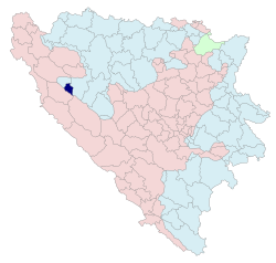
 Location of Istočni Drvar within Bosnia and Herzegovina Location of Istočni Drvar within Bosnia and Herzegovina | |
 | |
| Coordinates: 44°23′22″N 16°37′25″E / 44.38944°N 16.62361°E / 44.38944; 16.62361 | |
| Country | |
| Entity | |
| Geographical region | Bosanska Krajina |
| Government | |
| • Mayor | Milka Ivanković (SNSD) |
| Area | |
| • Total | 75.3 km (29.1 sq mi) |
| Population | |
| • Total | 105 |
| • Density | 1.4/km (3.6/sq mi) |
| Time zone | UTC+1 (CET) |
| • Summer (DST) | UTC+2 (CEST) |
| Area code | 51 |
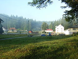
Istočni Drvar (Serbian Cyrillic: Источни Дрвар) is a municipality located in Republika Srpska, Bosnia and Herzegovina. it is situated in the central part of the Bosanska Krajina region. The seat of the municipality is in the village of Potoci.
History
In 1995, following the end of the Bosnian War, Istočni Drvar was created from part of the pre-war municipality of Drvar (the other part of the pre-war municipality is now in the Federation of Bosnia and Herzegovina). During the war, it was also known as Srpski Drvar (Српски Дрвар).
As of 2019, it is the smallest municipality by number of inhabitants in Republika Srpska and the whole of Bosnia and Herzegovina.
Geography
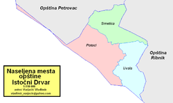
It is located in a densely wooded area between municipalities of Petrovac in the north-west, Ribnik in the east, and Drvar in the south.
Demographics
Population
| Population of settlements – Istočni Drvar municipality | |||
|---|---|---|---|
| Settlement | 1991. | 2013. | |
| Total | 79 | ||
| 1 | Potoci | 61 | 66 |
Ethnic composition
| Ethnic composition – Istočni Drvar municipality (2013) | |||||||
|---|---|---|---|---|---|---|---|
| Total | 79 (100.0%) | ||||||
| Serbs | 78 (98.73%) | ||||||
| Croats | 1 (1.266%) | ||||||
See also
References
- "Istočni Drvar (Municipality, Bosnia and Herzegovina) - Population Statistics, Charts, Map and Location". www.citypopulation.de. Retrieved 2023-08-22.
- ^ Milojević, Milkica (30 June 2019). "PATULJASTE OPŠTINE U SRPSKOJ Tri sela, sto stanovnika i gradonačelnica". srpskainfo.com (in Serbian). Retrieved 25 August 2019.
External links
This article about a location in the municipality of Istočni Drvar, Republika Srpska is a stub. You can help Misplaced Pages by expanding it. |
