| Jarrier | |
|---|---|
| Commune | |
 The Saint-Roch Chapel in 2015 The Saint-Roch Chapel in 2015 | |
| Location of Jarrier | |
  | |
| Coordinates: 45°16′52″N 6°19′03″E / 45.2811°N 6.3175°E / 45.2811; 6.3175 | |
| Country | France |
| Region | Auvergne-Rhône-Alpes |
| Department | Savoie |
| Arrondissement | Saint-Jean-de-Maurienne |
| Canton | Saint-Jean-de-Maurienne |
| Government | |
| • Mayor (2020–2026) | Marc Picton |
| Area | 17.79 km (6.87 sq mi) |
| Population | 502 |
| • Density | 28/km (73/sq mi) |
| Time zone | UTC+01:00 (CET) |
| • Summer (DST) | UTC+02:00 (CEST) |
| INSEE/Postal code | 73138 /73300 |
| Elevation | 760–2,173 m (2,493–7,129 ft) |
| French Land Register data, which excludes lakes, ponds, glaciers > 1 km (0.386 sq mi or 247 acres) and river estuaries. | |
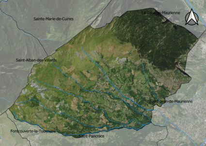
Jarrier (French pronunciation: [ʒaʁje]; Arpitan: Jarriér) is a commune in the Savoie department in the Auvergne-Rhône-Alpes region in south-eastern France.
Geography
Climate
According to a 2010 study by the French National Centre for Scientific Research, the commune is situated in a "mountain climate". In 2020, Météo-France published its own typology of French climates in which it categorized the commune's climate as a mountain climate or mountain margins climate within the Northern Alps climate region.
From 1971 to 2000, the average annual temperature was 8.3 °C (46.9 °F), with an annual range of 17.4 °C (63.3 °F). The average annual rainfall was 1,156 millimetres (45.5 in), with 9.7 days of rainfall in January and 8.9 days of rainfall in July.
Demographics
According to France's National Institute of Statistics and Economic Studies, the commune had a population of 499 in 2021, up from 497 in 2015. The age distribution was skewed towards the elderly, with 13.5% of the population aged 14 and under, 9.3% aged 15−29, 16% aged 30−44, 22.4% aged 45−59, 27.4% aged 60−74, and 11.5% aged 75 or higher. Since 2015, the population of the 60−74 and 75+ age ranges had increased while the younger age ranges had decreased in population.
The commune had 153 single-family households, 56.1% of which were couples without children. 37.3% were couples with children, and a further 6.6% were single-parent households. 87.8% of permanent residences were owned by their occupants, while 9.7% were rented. The median disposable household income was €26,000.
See also
References
- "Répertoire national des élus: les maires". data.gouv.fr, Plateforme ouverte des données publiques françaises (in French). 2 December 2020.
- "Populations de référence 2022" (in French). The National Institute of Statistics and Economic Studies. 19 December 2024.
- ^ Daniel Joly, Thierry Brossard, Hervé Cardot, Jean Cavailhes, Mohamed Hilal et Pierre Wavresky (18 June 2010), "Les types de climats en France, une construction spatiale", Cybergéo, revue européenne de géographie - European Journal of Geography (in French), no. 501, doi:10.4000/cybergeo.23155, retrieved 29 July 2024
{{citation}}: CS1 maint: multiple names: authors list (link) - "Zonages climatiques en France métropolitaine". pluiesextremes.meteo.fr (in French). Retrieved 29 July 2024.
- ^ "Dossier complet Commune de Jarrier (73138)". Institut national de la statistique et des études économiques (in French). Retrieved 12 December 2024.
This Savoie geographical article is a stub. You can help Misplaced Pages by expanding it. |

