| Jarud Banner 扎鲁特旗 • ᠵᠠᠷᠤᠳ ᠬᠣᠰᠢᠭᠤ | |
|---|---|
| Banner | |
 | |
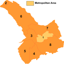
 Tongliao divisions: Jarud Banner is 6 on this map Tongliao divisions: Jarud Banner is 6 on this map | |
  | |
| Coordinates: 44°33′N 120°55′E / 44.550°N 120.917°E / 44.550; 120.917 | |
| Country | China |
| Autonomous region | Inner Mongolia |
| Prefecture-level city | Tongliao |
| Banner seat | Lubei |
| Area | |
| • Total | 16,490 km (6,370 sq mi) |
| Elevation | 264 m (866 ft) |
| Population | |
| • Total | 251,806 |
| • Density | 15/km (40/sq mi) |
| Time zone | UTC+8 (China Standard) |
| Website | www |
| Jarud Banner | |||||||
|---|---|---|---|---|---|---|---|
| Chinese name | |||||||
| Simplified Chinese | 扎鲁特旗 | ||||||
| Traditional Chinese | 扎魯特旗 | ||||||
| |||||||
| Mongolian name | |||||||
| Mongolian Cyrillic | Жаруд хошуу | ||||||
| Mongolian script | ᠵᠠᠷᠤᠳ ᠬᠣᠰᠢᠭᠤ | ||||||
| |||||||
Jarud Banner (Mongolian: ᠵᠠᠷᠤᠳ ᠬᠣᠰᠢᠭᠤ; Chinese: 扎鲁特旗) is a banner of eastern Inner Mongolia, China. It is under the administration of Tongliao City, 150 kilometres (93 mi), and the China National Highway 304 passes through the area.
Demographics
| ||||||||||||||||||||||||||||||||||||||||
Administrative divisions
Jarud Banner is made up of 7 towns, 8 sums, and 4 farm and pasture areas.
| Name | Simplified Chinese | Hanyu Pinyin | Mongolian (Hudum Script) | Mongolian (Cyrillic) | Administrative division code |
|---|---|---|---|---|---|
| Towns | |||||
| Lubei Town | 鲁北镇 | Lǔběi Zhèn | ᠯᠦᠪᠧᠢ ᠪᠠᠯᠭᠠᠰᠤ | Лүбей балгас | 150526100 |
| Huanghuashan Town | 黄花山镇 | Huánghuāshān Zhèn | ᠬᠤᠸᠠᠩ ᠬᠤᠸᠠ ᠱᠠᠨ ᠪᠠᠯᠭᠠᠰᠤ | Хуан ухаа шин балгас | 150526101 |
| Gahait Town | 嘎亥图镇 | Gāhàitú Zhèn | ᠭᠠᠬᠠᠢᠲᠤ ᠪᠠᠯᠭᠠᠰᠤ | Гахайт балгас | 150526102 |
| Jurh Town | 巨日合镇 | Jùrìhé Zhèn | ᠵᠢᠷᠦᠬᠡ ᠪᠠᠯᠭᠠᠰᠤ | Зүрх балгас | 150526103 |
| Bayart Huxu Town | 巴雅尔吐胡硕镇 | Bāyǎ'ěrtǔhúshuò Zhèn | ᠪᠠᠶᠠᠷᠲᠤᠬᠤᠰᠢᠭᠤ ᠪᠠᠯᠭᠠᠰᠤ | Баяртхошуу балгас | 150526104 |
| Xiangshan Town | 香山镇 | Xiāngshān Zhèn | ᠰᠢᠶᠠᠩ ᠱᠠᠨ ᠪᠠᠯᠭᠠᠰᠤ | Шиян шин балгас | 150526105 |
| Ar Hondlon Town | 阿日昆都楞镇 | Ārìkūndūléng Zhèn | ᠠᠷᠤ ᠬᠥᠨᠳᠡᠯᠡᠨ ᠪᠠᠯᠭᠠᠰᠤ | Ар хөндлөн балгас | 150526106 |
| Sums | |||||
| Bayan Tal Sum | 巴彦塔拉苏木 | Bāyàntǎlā Sūmù | ᠪᠠᠶᠠᠨᠲᠠᠯᠠ ᠰᠤᠮᠤ | Баянтөл сум | 150526200 |
| Olji Moron Sum | 乌力吉木仁苏木 | Wūlìjímùrén Sūmù | ᠥᠯᠵᠡᠢᠮᠦ᠋ᠷᠡᠨ ᠰᠤᠮᠤ | Өлзиймран сум | 150526201 |
| Dolod Sum | 道老杜苏木 | Dàolǎodù Sūmù | ᠳᠣᠯᠣᠳᠤ ᠰᠤᠮᠤ | Долду сум | 150526202 |
| Ger Qulu Sum | 格日朝鲁苏木 | Gérìcháolǔ Sūmù | ᠭᠡᠷᠴᠢᠯᠠᠭᠤ ᠰᠤᠮᠤ | Хэрчлуу сум | 150526203 |
| Qandmun Sum | 前德门苏木 | Qiándémén Sūmù | ᠴᠢᠨᠳᠠᠮᠤᠨᠢ ᠰᠤᠮᠤ | Чандмэнэ сум | 150526204 |
| Ulan Had Sum | 乌兰哈达苏木 | Wūlánhādá Sūmù | ᠤᠯᠠᠭᠠᠨᠬᠠᠳᠠ ᠰᠤᠮᠤ | Улаанахта сум | 150526205 |
| Qabagt Sum | 查布嘎图苏木 | Chábùgātú Sūmù | ᠴᠢᠪᠠᠭᠠᠲᠤ ᠰᠤᠮᠤ | Чавгаат сум | 150526206 |
| Unegq Sum | 乌额格其苏木 | Wū'égéqí Sūmù | ᠦᠨᠡᠭᠡᠴᠢ ᠰᠤᠮᠤ | Үнэгч сум | 150526207 |
| Others | |||||
| Unegq Pasture | 乌额格其牧场 | Wū’égéqí Mùchǎng | ᠦᠨᠡᠭᠡᠴᠢ ᠮᠠᠯᠵᠢᠯ ᠤᠨ ᠲᠠᠯᠠᠪᠠᠢ | Үнэгч малжлын талбай | 150526400 |
| Xiangshan Farm | 香山农场 | Xiāngshān Nóngchǎng | ᠰᠢᠶᠠᠩ ᠱᠠᠨ ᠲᠠᠷᠢᠶᠠᠯᠠᠩ ᠤᠨ ᠲᠠᠯᠠᠪᠠᠢ | Шиян шин тариалангийн талбай | 150526401 |
| Orgon Tal Farm | 乌日根塔拉农场 | Wūrìgēntǎlā Nóngchǎng | ᠥᠷᠭᠡᠨᠲᠠᠯᠠ ᠲᠠᠷᠢᠶᠠᠯᠠᠩ ᠤᠨ ᠲᠠᠯᠠᠪᠠᠢ | Өргөндлөө тариалангийн талбай | 150526402 |
| Gadas Breeding Stock Farm | 嘎达苏种畜场 | Gādásū Zhǒngxùchǎng | ᠭᠠᠳᠠᠰᠤ ᠦᠷᠡᠰ ᠦᠨ ᠮᠠᠯᠵᠢᠯ ᠤᠨ ᠲᠠᠯᠠᠪᠠᠢ | Гадас үрсийн малжлын талбай | 150526403 |
Climate
Jarud Banner has a monsoon-influenced, continental semi-arid climate (Köppen BSk), with very cold and dry winters, hot, somewhat humid summers, and strong winds, especially in spring. The monthly 24-hour average temperature ranges from −12.2 °C (10.0 °F) in January to 24.1 °C (75.4 °F) in July, with the annual mean at 7.06 °C (44.7 °F). The annual precipitation is 362 millimetres (14.3 in), with more than half of it falling in July and August alone. There are 2,883 hours of bright sunshine annually, with each of the winter months having over two-thirds of the possible total, and this percentage falling to 54 in July.
| Climate data for Jarud Banner (1991–2020 normals) | |||||||||||||
|---|---|---|---|---|---|---|---|---|---|---|---|---|---|
| Month | Jan | Feb | Mar | Apr | May | Jun | Jul | Aug | Sep | Oct | Nov | Dec | Year |
| Record high °C (°F) | 9.1 (48.4) |
17.4 (63.3) |
29.3 (84.7) |
35.4 (95.7) |
39.3 (102.7) |
43.7 (110.7) |
40.5 (104.9) |
38.7 (101.7) |
36.1 (97.0) |
30.6 (87.1) |
20.8 (69.4) |
11.8 (53.2) |
43.7 (110.7) |
| Mean daily maximum °C (°F) | −6.0 (21.2) |
−1.1 (30.0) |
6.6 (43.9) |
16.5 (61.7) |
24.0 (75.2) |
28.4 (83.1) |
30.2 (86.4) |
28.8 (83.8) |
23.8 (74.8) |
14.9 (58.8) |
3.2 (37.8) |
−4.7 (23.5) |
13.7 (56.7) |
| Daily mean °C (°F) | −11.8 (10.8) |
−7.6 (18.3) |
−0.1 (31.8) |
9.7 (49.5) |
17.4 (63.3) |
22.4 (72.3) |
24.8 (76.6) |
22.9 (73.2) |
16.8 (62.2) |
7.9 (46.2) |
−2.7 (27.1) |
−10.2 (13.6) |
7.5 (45.4) |
| Mean daily minimum °C (°F) | −16.1 (3.0) |
−12.7 (9.1) |
−5.9 (21.4) |
3.1 (37.6) |
10.9 (51.6) |
16.6 (61.9) |
19.7 (67.5) |
17.7 (63.9) |
10.8 (51.4) |
2.3 (36.1) |
−7.3 (18.9) |
−14.3 (6.3) |
2.1 (35.7) |
| Record low °C (°F) | −27.7 (−17.9) |
−26.96 (−16.53) |
−18.4 (−1.1) |
−8.6 (16.5) |
−0.4 (31.3) |
4.7 (40.5) |
11.6 (52.9) |
8.5 (47.3) |
0.2 (32.4) |
−13.5 (7.7) |
−20.7 (−5.3) |
−26.1 (−15.0) |
−27.7 (−17.9) |
| Average precipitation mm (inches) | 0.7 (0.03) |
0.8 (0.03) |
3.5 (0.14) |
10.1 (0.40) |
33.7 (1.33) |
75.1 (2.96) |
121.7 (4.79) |
77.0 (3.03) |
29.4 (1.16) |
12.7 (0.50) |
2.6 (0.10) |
1.7 (0.07) |
369 (14.54) |
| Average precipitation days (≥ 0.1 mm) | 1.7 | 0.9 | 2.2 | 3.5 | 6.7 | 11.4 | 11.4 | 9.4 | 6.2 | 3.7 | 2.0 | 1.9 | 61 |
| Average snowy days | 2.5 | 2.1 | 3.1 | 1.2 | 0 | 0 | 0 | 0 | 0 | 0.7 | 3.0 | 2.9 | 15.5 |
| Average relative humidity (%) | 44 | 38 | 35 | 32 | 38 | 53 | 64 | 64 | 53 | 45 | 45 | 47 | 47 |
| Mean monthly sunshine hours | 209.2 | 223.0 | 268.1 | 262.6 | 271.2 | 243.3 | 229.9 | 246.5 | 244.2 | 236.2 | 194.5 | 187.0 | 2,815.7 |
| Percent possible sunshine | 73 | 75 | 72 | 65 | 59 | 52 | 49 | 57 | 66 | 71 | 68 | 69 | 65 |
| Source: China Meteorological Administration | |||||||||||||
| Climate data for Bayaertuhushuo Town, Jarud Banner, elevation 628 m (2,060 ft), (1991–2020 normals) | |||||||||||||
|---|---|---|---|---|---|---|---|---|---|---|---|---|---|
| Month | Jan | Feb | Mar | Apr | May | Jun | Jul | Aug | Sep | Oct | Nov | Dec | Year |
| Mean daily maximum °C (°F) | −9.5 (14.9) |
−4.7 (23.5) |
3.0 (37.4) |
13.3 (55.9) |
21.1 (70.0) |
25.4 (77.7) |
27.4 (81.3) |
26.1 (79.0) |
21.2 (70.2) |
12.2 (54.0) |
0.4 (32.7) |
−7.8 (18.0) |
10.7 (51.2) |
| Daily mean °C (°F) | −15.6 (3.9) |
−11.6 (11.1) |
−3.9 (25.0) |
6.3 (43.3) |
14.2 (57.6) |
19.1 (66.4) |
21.6 (70.9) |
19.6 (67.3) |
13.5 (56.3) |
4.8 (40.6) |
−6.1 (21.0) |
−13.7 (7.3) |
4.0 (39.2) |
| Mean daily minimum °C (°F) | −20.5 (−4.9) |
−17.5 (0.5) |
−10.4 (13.3) |
−1.2 (29.8) |
6.5 (43.7) |
12.3 (54.1) |
15.9 (60.6) |
13.4 (56.1) |
6.3 (43.3) |
−1.7 (28.9) |
−11.6 (11.1) |
−18.6 (−1.5) |
−2.3 (27.9) |
| Average precipitation mm (inches) | 0.8 (0.03) |
1.7 (0.07) |
4.6 (0.18) |
8.8 (0.35) |
34.7 (1.37) |
89.5 (3.52) |
123 (4.8) |
82.8 (3.26) |
36.6 (1.44) |
13.9 (0.55) |
3.7 (0.15) |
1.8 (0.07) |
401.9 (15.79) |
| Average precipitation days (≥ 0.1 mm) | 1.3 | 1.6 | 3.1 | 4.4 | 7.8 | 13.6 | 14.1 | 11.0 | 7.3 | 4.2 | 3.1 | 2.2 | 73.7 |
| Average snowy days | 3.9 | 3.5 | 6.2 | 3.8 | 0.5 | 0.1 | 0 | 0 | 0.4 | 2.7 | 5.4 | 5.5 | 32 |
| Average relative humidity (%) | 54 | 49 | 44 | 36 | 40 | 59 | 70 | 70 | 59 | 49 | 53 | 56 | 53 |
| Mean monthly sunshine hours | 231.7 | 243.1 | 291.8 | 288.5 | 294.4 | 256.0 | 246.5 | 262.6 | 263.1 | 254.9 | 210.5 | 207.3 | 3,050.4 |
| Percent possible sunshine | 81 | 82 | 78 | 71 | 64 | 55 | 53 | 61 | 71 | 76 | 75 | 76 | 70 |
| Source: China Meteorological Administration | |||||||||||||

See also
References
- Inner Mongolia: Prefectures, Cities, Districts and Counties
- 内蒙古自治区第七次全国人口普查领导小组办公室、内蒙古自治区统计局. "内蒙古人口普查年鉴-2020".
- ^ 中国气象数据网 – WeatherBk Data (in Simplified Chinese). China Meteorological Administration. Retrieved 10 October 2023.
- 中国气象数据网 (in Simplified Chinese). China Meteorological Administration. Retrieved 10 October 2023.
- 中国地面国际交换站气候标准值月值数据集(1971-2000年). China Meteorological Administration. Archived from the original on 2013-09-21. Retrieved 2010-05-25.
- 中国气象数据网 (in Simplified Chinese). China Meteorological Administration. Retrieved 10 October 2023.
External links
- www.xzqh.org (in Chinese)
| County-level divisions of Inner Mongolia Autonomous Region | |||||||||||||||||||
|---|---|---|---|---|---|---|---|---|---|---|---|---|---|---|---|---|---|---|---|
| Hohhot (capital) | |||||||||||||||||||
| Prefecture-level cities |
| ||||||||||||||||||
| Leagues |
| ||||||||||||||||||
This Inner Mongolia location article is a stub. You can help Misplaced Pages by expanding it. |