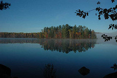
| Joeperry Lake | |
|---|---|
 | |
 | |
| Location | Addington Highlands, Lennox and Addington County, Ontario |
| Coordinates | 44°54′48″N 77°17′45″W / 44.91333°N 77.29583°W / 44.91333; -77.29583 |
| Primary inflows | One unnamed creek |
| Primary outflows | Skootamatta River |
| Basin countries | Canada |
| Max. length | 2.2 km (1.4 mi) |
| Max. width | 1.4 km (0.87 mi) |
| Surface elevation | 315 m (1,033 ft) |
Joeperry Lake is a lake in the Lake Ontario drainage basin in Addington Highlands, Lennox and Addington County, Ontario, Canada. It measures approximately 13 kilometres (8 mi) northwest of Cloyne and is within Bon Echo Provincial Park.
Joeperry Lake is the source of the Skootamatta River. It is about 2.2 kilometres (1.4 mi) long and 2.2 kilometres (1.4 mi) wide, and lies at an elevation of 315 metres (1,033 ft). There is one inflow, an unnamed creek at the west of the lake. The primary outflow is the Skootamatta River, on the south side of the lake, south to Pearson Lake; a marsh at the east of the lake also connects to Pearson Lake. The Skootamatta River flows via the Moira River into the Bay of Quinte on Lake Ontario.
See also
References
- "Joeperry Lake". Geographical Names Data Base. Natural Resources Canada. Retrieved 2010-03-02.
- "Toporama - Topographic Map Sheet 31C14". Atlas of Canada. Natural Resources Canada. Archived from the original on 2010-02-10. Retrieved 2010-03-02.
This Eastern Ontario geographical article is a stub. You can help Misplaced Pages by expanding it. |