| Kaki Thalassa Κακή Θάλασσα | |
|---|---|
| Settlement | |
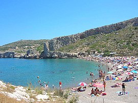
 A beach on the sea the town is named for A beach on the sea the town is named for | |
 | |
| Coordinates: 37°50′19″N 24°2′54″E / 37.83861°N 24.04833°E / 37.83861; 24.04833 | |
| Country | Greece |
| Administrative region | Attica |
| Regional unit | East Attica |
| Municipality | Lavreotiki |
| Municipal unit | Keratea |
| Elevation | 23 m (75 ft) |
| Population | |
| • Total | 165 |
| Time zone | UTC+2 (EET) |
| • Summer (DST) | UTC+3 (EEST) |
Kaki Thalassa (Greek: Κακή Θάλασσα) is a Mediterranean port town located in the municipality of Lavreotiki, East Attica, Greece, 30 km southeast of the nation's capital, Athens. Kaki Thalassa is 23 meters (75 ft) above sea level. A rural town, it had a total population of 165 according to the 2021 Greek census.
Prior to the 2011 Kallikratis local government reform program, Kaki Thalassa was part of the municipality of Keratea.
The town's name, literally translated, means evil sea, from κακή (the nominative singular form of κακός), meaning bad or evil, and the (feminine gendered) noun θάλασσα, meaning sea.
Climate
| Kaki Thalassa (Κακή Θάλασσα) | ||||||||||||||||||||||||||||||||||||||||||||||||||||||||||||
|---|---|---|---|---|---|---|---|---|---|---|---|---|---|---|---|---|---|---|---|---|---|---|---|---|---|---|---|---|---|---|---|---|---|---|---|---|---|---|---|---|---|---|---|---|---|---|---|---|---|---|---|---|---|---|---|---|---|---|---|---|
| Climate chart (explanation) | ||||||||||||||||||||||||||||||||||||||||||||||||||||||||||||
| ||||||||||||||||||||||||||||||||||||||||||||||||||||||||||||
| ||||||||||||||||||||||||||||||||||||||||||||||||||||||||||||
References
- ^ "Αποτελέσματα Απογραφής Πληθυσμού - Κατοικιών 2021, Μόνιμος Πληθυσμός κατά οικισμό" [Results of the 2021 Population - Housing Census, Permanent population by settlement] (in Greek). Hellenic Statistical Authority. 29 March 2024.
- "ΦΕΚ B 1292/2010, Kallikratis reform municipalities" (in Greek). Government Gazette.
- NASA Earth Observations
This Attica location article is a stub. You can help Misplaced Pages by expanding it. |