| Kang Nachugo | |
|---|---|
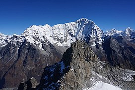
 Kang Nachugo in 2016 Kang Nachugo in 2016 | |
| Highest point | |
| Elevation | 6,735 m (22,096 ft) |
| Prominence | 935 m (3,068 ft) |
| Coordinates | 27°54′18″N 86°26′33″E / 27.90500552217589°N 86.44248796855057°E / 27.90500552217589; 86.44248796855057 |
| Geography | |
  | |
| Country | Nepal |
| Province | Bagmati |
| District | Dolakha |
Kang Nachugo is a mountain located in Gaurishankar, Dolakha District, Nepal at an elevation of 6,735 metres (22,096 ft) above sea level. It was first climbed in 2008 by Joe Puryear, and David Gottlieb.
References
- ^ "The First Ascent of Kang Nachugo". Climbing. 14 November 2008. Archived from the original on 25 March 2021. Retrieved 25 March 2021.
- "Takargo: Rolwaling's Hidden Gem". Alpinist. 8 April 2010. Archived from the original on 25 March 2021. Retrieved 25 March 2021.
- "Kang Nachugo first ascent for Joe Puryear & David Gottlieb". PlanetMountain. Archived from the original on 25 March 2021. Retrieved 25 March 2021.
- "AAC Publications - Kang Nachugo, South Face and West Ridge". American Alpine Club. Archived from the original on 25 March 2021. Retrieved 25 March 2021.
This article related to a mountain or hill in Nepal is a stub. You can help Misplaced Pages by expanding it. |