| Kantunilkín | |
|---|---|
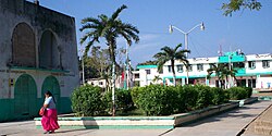
 Central plaza Central plaza | |
 | |
| Coordinates: 21°06′N 87°29′W / 21.100°N 87.483°W / 21.100; -87.483 | |
| Country | Mexico |
| State | Quintana Roo |
| Municipality | Lázaro Cárdenas |
| Established | 1850 |
| Government | |
| • Municipal President | Clementino Angulo Cupul |
| Population | |
| • Total | 7,150 |
| Time zone | UTC-5 (Eastern Standard Time) |
Kantunilkín is the municipal seat and largest city in Lázaro Cárdenas in the Mexican state of Quintana Roo. According to the 2010 census, the city's population was 7,150 persons.
Kantunilkín was established in 1850 by Mayan Cruzobs during the Caste War of Yucatán, and originally called Nueva Santa Cruz–Kantunil. In 1859, the inhabitants accepted the general amnesty and the place was granted recognition by the Mexican government.
References
- 2010 census tables: INEGI Archived 2013-05-02 at the Wayback Machine
External links
 Media related to Kantunilkín at Wikimedia Commons
| Chetumal (capital) | |||||||||||
| Municipalities (seats) |
|  | |||||||||
| Places of interest |
| ||||||||||
This article about a location in the Mexican state of Quintana Roo is a stub. You can help Misplaced Pages by expanding it. |