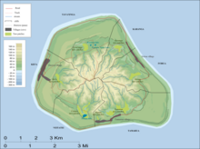
Karanga is the smallest of the six traditional districts of the island of Mangaia, in the Cook Islands archipelago. Karanga is located in the northeast of the island, to the east of the District of Tava'enga and northwest of the District of Ivirua. The district was traditionally divided into 5 tapere:
- Kaau-i-uta
- Kaau-i-miri
- Teia-pini
- Teia-poto
- Teia-roa
Mangaia Airport is located in this district.
References
- ^ Te Rangi Hiroa (1934). Mangaian Society. Honolulu: Bernice P. Bishop Museum. p. 126. Retrieved 9 August 2020 – via NZETC.
21°54′22.83″S 157°54′11.15″W / 21.9063417°S 157.9030972°W / -21.9063417; -157.9030972
This Cook Islands location article is a stub. You can help Misplaced Pages by expanding it. |