| This article does not cite any sources. Please help improve this article by adding citations to reliable sources. Unsourced material may be challenged and removed. Find sources: "Karimala Gopuram" – news · newspapers · books · scholar · JSTOR (September 2017) (Learn how and when to remove this message) |
| Karimala Gopuram കരിമല ഗോപുരം | |
|---|---|
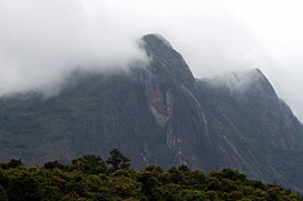
 View of Karimala Gopuram View of Karimala Gopuram | |
| Highest point | |
| Elevation | 1,439 m (4,721 ft) |
| Listing | List of highest point in Kerala by districts |
| Coordinates | 10°21′58.47″N 76°44′48.43″E / 10.3662417°N 76.7467861°E / 10.3662417; 76.7467861 |
| Geography | |
 കരിമല ഗോപുരംLocation in Kerala | |
| Location | Border of Chalakudy taluk, Thrissur district and Chittur taluk, Palakkad district, Kerala, India |
| Parent range | Western Ghats |
Karimala Gopuram (കരിമല ഗോപുരം) is the highest peak in the Thrissur district of Kerala. It is located at southern boundary of Parambikulam Wildlife Sanctuary. It lies in the border of Chalakudy taluk of Thrissur district and Chittur taluk of Palakkad district of Kerala. It is about 1,439m above sea level in the Western Ghats.
This article related to a location in Thrissur district, Kerala, India is a stub. You can help Misplaced Pages by expanding it. |
This Asia mountain, mountain range, or peak related article is a stub. You can help Misplaced Pages by expanding it. |