Municipality in Greece
| Karpenisi Καρπενήσι | |
|---|---|
| Municipality | |
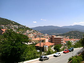
 Part of the town Part of the town | |
  | |
| Coordinates: 38°55′N 21°47′E / 38.917°N 21.783°E / 38.917; 21.783 | |
| Country | Greece |
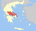
| Administrative region | Central Greece |
| Regional unit | Evrytania |
| Government | |
| • Mayor | Christos Kakavas (since 2023) |
| Area | |
| • Municipality | 948.6 km (366.3 sq mi) |
| • Municipal unit | 250.9 km (96.9 sq mi) |
| Elevation | 960 m (3,150 ft) |
| Population | |
| • Municipality | 11,445 |
| • Density | 12/km (31/sq mi) |
| • Municipal unit | 7,921 |
| • Municipal unit density | 32/km (82/sq mi) |
| • Community | 6,788 |
| Time zone | UTC+2 (EET) |
| • Summer (DST) | UTC+3 (EEST) |
| Postal code | 361 00 |
| Area code(s) | 22370 |
| Vehicle registration | ΚΗ |
| Website | www.karpenissi.gr |
Karpenisi (Greek: Καρπενήσι, Greek pronunciation: [karpeˈnisi]) is a town in central Greece. It is the capital of the regional unit of Evrytania. Karpenisi is situated in the valley of the river Karpenisiotis (Καρπενησιώτης), a tributary of the Megdovas, in the southern part of the Pindus Mountains. Mount Tymfristos (2,315 m elevation) lies directly to the north of the town, and the foothills of mount Kaliakouda are in the south. Karpenisi has a ski resort and is a popular destination, especially during winter. It is called Switzerland of Greece for the resemblance with the mountainous country and its beauty, atypical for a Mediterranean place.
Etymology
The name Karpenisi derives from the Aromanian word kárpinu 'hornbeam' + the ending -iş. The Greek spelling Καρπενήσι is influenced by folk etymology, the second combining form appearing to be νησί 'island' (pronounced ). The first mention of the name is traced back to an Ottoman tax ledger of 1454–1455.
Municipality


The municipality Karpenisi was formed at the 2011 local government reform by the merger of the following 6 former municipalities, that became municipal units:
- Domnista (Ampliani, Domnista, Krikello, Mesokomi, Psiana, Roska, Stavloi)
- Fourna (Fourna, Kleisto, Vracha)
- Karpenisi (Agia Vlacherna, Agios Andreas, Agios Nikolaos, Fidakia, Kalesmeno, Karpenisi, Koryschades, Myriki, Papparousi, Pavlopoulo, Sella, Stefani, Stenoma, Voutyro)
- Ktimenia (Agia Triada, Agios Charalampos, Chochlia, Domianoi, Petralona)
- Potamia (Aniada, Chelidonas, Dermati, Karitsa, Klafsi, Megalo Chorio, Mikro Chorio, Mouzilo, Nostimo, Sygkrellos)
- Prousos (Alestia, Aspropyrgos, Esochoria, Kastania, Katavothra, Prodromos, Prousos, Sarkini, Stavrochori, Tornos, Velota)
The municipality has an area of 948.570 km, the municipal unit 250.887 km.
Mayor of Karpenisi
- Kostas Bakoyannis, 2011–2014
- Nikos Souliotis, 2014–2023
- Christos Kakavas, since 2024
History
Karpenisi has a lot of history in the region. In antiquity, Karpenisi was known as Oechalia and ruled by king Evrytos, inventor of the bow.
During the Greek Revolution of 1821, the towns mountainous location was of strategic importance for central Roumeli. During more recent times, the region took part in WWI and WWII, becoming the place where the armed National Resistance was initiated. Karpenisi was badly damaged by Italian and German attacks during WWII.
Climate
Due to its altitude, Karpenisi has a temperate climate (Köppen: C), with abundant rainfall year round and much cooler temperatures. Snowfall is frequent and heavy in winter, whereas summers are pleasantly warm with cool nights.
| Climate data for Karpenisi town weather station (998m) | |||||||||||||
|---|---|---|---|---|---|---|---|---|---|---|---|---|---|
| Month | Jan | Feb | Mar | Apr | May | Jun | Jul | Aug | Sep | Oct | Nov | Dec | Year |
| Mean daily maximum °C (°F) | 6 (43) |
8.9 (48.0) |
12.1 (53.8) |
14.4 (57.9) |
20.3 (68.5) |
24.5 (76.1) |
27.4 (81.3) |
28.5 (83.3) |
24.2 (75.6) |
19.9 (67.8) |
13 (55) |
10.5 (50.9) |
17.5 (63.4) |
| Mean daily minimum °C (°F) | −1.7 (28.9) |
0.2 (32.4) |
2.2 (36.0) |
4.4 (39.9) |
8.5 (47.3) |
12.7 (54.9) |
15.5 (59.9) |
16.4 (61.5) |
13.3 (55.9) |
9 (48) |
5.5 (41.9) |
2 (36) |
7.3 (45.2) |
| Average precipitation mm (inches) | 164.7 (6.48) |
108.7 (4.28) |
107.5 (4.23) |
101.2 (3.98) |
58.5 (2.30) |
54.8 (2.16) |
62.2 (2.45) |
39.7 (1.56) |
171.6 (6.76) |
76.7 (3.02) |
145 (5.7) |
179.7 (7.07) |
1,270.3 (49.99) |
| Source: http://penteli.meteo.gr/stations/karpenisitown/ (2019 - 2020 averages) | |||||||||||||
Historical population
| Year | Municipal unit | Municipality |
|---|---|---|
| 1981 | 5,230 | – |
| 1991 | 8,185 | – |
| 2001 | 9,390 | – |
| 2011 | 8,575 | 13,105 |
| 2021 | 7,921 | 11,445 |
Sister cities
 Asheville, United States
 Messolonghi, Greece
 Engomi, Cyprus
Notable people
- Zacharias Papantoniou (1877–1940), writer
- Ioannis Theodoropoulos, bronze medal in the pole vault 1896 Summer Olympics
- Georgios Kondylis (1878–1936), General of the Greek army and Prime Minister of Greece
- Charalambos Katsimitros (1886–1962), General of the Greek army who distinguished himself during the Greco-Italian War
- Pavlos Bakoyannis (1935–1989), Greek politician and journalist
Notable events
- Battle of Karpenisi (8 August 1823) during the Greek War of Independence
References
- "Municipality of Karpenissi, Municipal elections – October 2023". Ministry of Interior.
- "Αποτελέσματα Απογραφής Πληθυσμού - Κατοικιών 2021, Μόνιμος Πληθυσμός κατά οικισμό" [Results of the 2021 Population - Housing Census, Permanent population by settlement] (in Greek). Hellenic Statistical Authority. 29 March 2024.
- Dana Facaros; Linda Theodorou (2003). Greece. New Holland Publishers. p. 382. ISBN 978-1-86011-898-2.
- Oikonomou Konstantinos, Zagori toponym, Doctoral thesis, Ioannina 1986, pp. 752–753.
- Beldiceanu, Nicoară; Vasiliu Năsturel, Petre Ștefan (1991). "Η Θεσσαλία στην περίοδο 1454/55–1506". ΘΕΣΣΑΛΙΚΟ ΗΜΕΡΟΛΟΓΙΟ (in Greek). 19: 105–106.
- "ΦΕΚ B 1292/2010, Kallikratis reform municipalities" (in Greek). Government Gazette.
- "Population & housing census 2001 (incl. area and average elevation)" (PDF) (in Greek). National Statistical Service of Greece. Archived from the original (PDF) on 21 September 2015.
- ^ "History - municipality of Karpenisi". Karpenisi. Retrieved 7 March 2022.
- "Karpenisi, Greece". Archived from the original on 25 July 2011. Retrieved 7 October 2010.
- "Σε μια συγκινητική τελετή στην πλατεία Μάρκου Μπότσαρη αδελφοποιήθηκαν οι Δήμοι Ι.Π. Μεσολογγίου και Καρπενησίου". 8 August 2022.
- "Διδυμοποιήσεις".
External links
| Administrative division of the Central Greece Region | ||
|---|---|---|
| Regional unit of Boeotia |  | |
| Regional unit of Euboea | ||
| Regional unit of Evrytania | ||
| Regional unit of Phocis | ||
| Regional unit of Phthiotis | ||
| ||
| Subdivisions of the municipality of Karpenisi | |
|---|---|
| Municipal unit of Domnista |
|
| Municipal unit of Fourna |
|
| Municipal unit of Karpenisi |
|
| Municipal unit of Ktimenia |
|
| Municipal unit of Potamia |
|
| Municipal unit of Prousos |
|