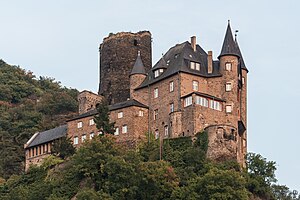

Katz Castle (German: Burg Katz) is a castle above the German town of Sankt Goarshausen in Rhineland-Palatinate. The castle stands on a ledge looking downstream from the riverside at Sankt Goar. It was first built around 1371 by Count William II of Katzenelnbogen. The castle was bombarded in 1806 by Napoleon and rebuilt in the late 19th century, in 1896–98. It is now privately owned, and not open for visitors.
Description
Etymology
After the original castle "Burg Katzenelnbogen" (lit. Castle Cat's Elbow) this medieval fortress castle is officially known as Burg Neukatzenelnbogen (Castle New Cat's Elbow). It used to be and still is, however, comfortably and commonly contracted to "die Katz" ("the Cat").
As such, it is popularly linked with Burg Maus ("the Mouse"), which was indeed erected in closest possible vicinity as its military counterpart.
Architecture
The castle is of compact layout, consisting mainly of a great hall and a massive bergfried, originally 40 metres tall, on the uphill side.
In 1435, the Counts of Katzenelnbogen were the first to plant Riesling grapes in their vineyard.
Katz Castle and its surroundings are the place of action for the Belgian comic book L'Orgue du Diable in the Yoko Tsuno series by Roger Leloup.
Gallery
-
 Southwest view
-
 The castle in the 1890s, before the reconstruction
-
 View from Lorelei rocks
-
 View from Lorelei harbor
-
 View from Rhine
Notes and references
External links
- Katz Castle
- Katz Castle in the Lorelei Valley
- Katz Castle near the Lorelei
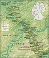
| Castles, Fortresses and Palaces in Germany - The Middle Rhine Valley (North to South) | ||
|---|---|---|
| Explanation of location |  | |
| Lower Middle Rhine Valley | ||
| Upper Middle Rhine Valley |
| |
50°09′06″N 7°43′27″E / 50.15167°N 7.72417°E / 50.15167; 7.72417
Categories: