You can help expand this article with text translated from the corresponding article in Finnish. (June 2023) Click for important translation instructions.
|
| Kauhaneva–Pohjankangas National Park | |
|---|---|
| IUCN category II (national park) | |
 Kauhaneva bog Kauhaneva bog | |
 | |
| Location | Finland |
| Coordinates | 62°10′45″N 22°24′23″E / 62.17917°N 22.40639°E / 62.17917; 22.40639 |
| Area | 57 km (22 sq mi) |
| Established | 1982 |
| Visitors | 6300 (in 2015) |
| Governing body | Metsähallitus |
| Website | www |
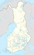
Kauhaneva–Pohjankangas National Park (Finnish: Kauhanevan–Pohjankankaan kansallispuisto) is a national park in the municipalities of Kauhajoki and Karvia in the Southern Ostrobothnia and Satakunta regions of Finland. Established in 1982, the park covers 57 square kilometres (22 sq mi). It consists of swamp areas, mainly bogs such as the 16.3-square-kilometre (6.3 sq mi) Kauhaneva bog, scattered around it.
In 2004, the park was included in the Ramsar Convention on Wetlands of International Importance. It is also part of the Natura 2000 network of protected areas.
Geography

The Kauhaneva–Pohjankangas area is part of the south-western region of the Suomenselkä watershed area. The soil is mostly turf and the bedrock is composed of porphyric granite.
The northern parts of Kauhaneva are 170 to 177 metres (558 to 581 ft) above sea level. The southern and western parts are approximately 160 metres (520 ft) above sea level.
See also
References
- "Käyntimäärät kansallispuistoittain" (in Finnish). Metsähallitus. 2016. Archived from the original on 29 May 2019. Retrieved 29 December 2016.
- Rinne, Jyri. "Maastopyöräily" (PDF). Kauhajoen metsien ja soiden kirja (in Finnish). p. 270. Archived from the original (PDF) on 2011-07-20. Retrieved 2009-01-24.
- "The Annotated Ramsar List: Finland". Ramsar. Archived from the original on April 30, 2008. Retrieved 2009-02-28.
- ^ "Suomen Natura 2000-alueet: Kauhaneva-Pohjankangas" (in Finnish). Finland's environmental administration. Retrieved 29 December 2016.
- "Stamps of Finnish Protected Areas". Metsähallitus. Retrieved 26 December 2016.
External links
 Media related to Kauhaneva–Pohjankangas National Park at Wikimedia Commons
- Outdoors.fi – Kauhaneva–Pohjankangas National Park
This Western Finland location article is a stub. You can help Misplaced Pages by expanding it. |
This article related to a protected area in Europe is a stub. You can help Misplaced Pages by expanding it. |
- IUCN Category II
- Protected areas established in 1982
- Ramsar sites in Finland
- Geography of South Ostrobothnia
- Geography of Satakunta
- Tourist attractions in South Ostrobothnia
- Tourist attractions in Satakunta
- 1982 establishments in Finland
- National parks of Finland
- Western Finland Province geography stubs
- European protected area stubs