| This article does not cite any sources. Please help improve this article by adding citations to reliable sources. Unsourced material may be challenged and removed. Find sources: "Kavieng District" – news · newspapers · books · scholar · JSTOR (August 2017) (Learn how and when to remove this message) |
| Kavieng District | |
|---|---|
 | |
 | |
| Coordinates: 2°34′18″S 150°48′17″E / 2.5718°S 150.8048°E / -2.5718; 150.8048 | |
| Country | Papua New Guinea |
| Province | New Ireland Province |
| Capital | Kavieng |
| LLGs | List |
| Government | |
| • MP | Ian Ling-Stuckey |
| Area | |
| • Total | 2,983 km (1,152 sq mi) |
| Population | |
| • Total | 83,162 |
| • Density | 28/km (72/sq mi) |
| Time zone | UTC+10 (AEST) |
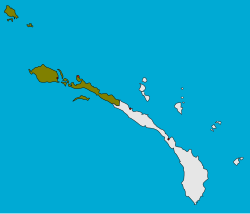
Kavieng District is the northernmost district of New Ireland Province in Papua New Guinea. The district contains the northern part of the island of New Ireland, as well as New Hannover, and the St. Matthias Group.
The district headquarters is Kavieng and the district has four LLG areas, Kavieng Urban LLG, Lavongai Rural LLG, Tikana Rural LLG and Murat Rural LLG.
| LLGs and districts of New Ireland Province of Papua New Guinea | ||
|---|---|---|
| Kavieng District | ||
| Namatanai District | ||