| This article needs additional citations for verification. Please help improve this article by adding citations to reliable sources. Unsourced material may be challenged and removed. Find sources: "Kel, Azad Kashmir" – news · newspapers · books · scholar · JSTOR (July 2019) (Learn how and when to remove this message) |
Village in Azad Kashmir, Pakistan
| Kel کیل | |
|---|---|
| Village | |
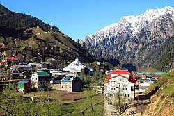
 A view of the village A view of the village | |
 | |
| Coordinates: 34°49′37″N 74°20′48″E / 34.826914°N 74.3466764°E / 34.826914; 74.3466764 | |
| Administering Country | |
| Self-governing jurisdiction | Azad Kashmir |
| District | Neelum |
| Government | |
| • Body | Azad Kashmir |
| Elevation | 2,097 m (6,879 ft) |
| Languages | |
| • Official | Urdu |
| • Local | Hindko, Kashmiri |
| Time zone | PST |
Kel (Urdu: کیل ) is a village in Neelum Valley, Azad Kashmir, Pakistan.
Transport
Buses run daily between Muzaffarabad and Kel.
A bus service also runs from Rawalpindi to Kel.
Facilities
Private hotels and a rest house, run by AJK Tourism and Archaeology Department, are available for tourists. It has a branch of Habib Bank Limited, boys and girls degree colleges, Tehsil Headquarter hospital and a bazaar.
See also
References
- "Neelum Valley". Azad Jammu & Kashmir Council. Archived from the original on 27 August 2013. Retrieved 7 October 2012.
External links
34°49′27″N 74°21′11″E / 34.8243°N 74.3531°E / 34.8243; 74.3531
Categories: