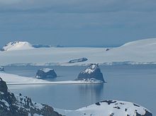


Kerseblept Nunatak (Nunatak Kerseblept \'nu-na-tak ker-se-'blept\) is a rocky hill of elevation 90 m projecting from Yakoruda Glacier on Greenwich Island in the South Shetland Islands, Antarctica. The hill is named after the Thracian king Cersobleptes, 359-341 BC.
Location
The hill is located at 62°29′16.5″S 59°57′18″W / 62.487917°S 59.95500°W / -62.487917; -59.95500 which is on the northeast coast of McFarlane Strait, 3.9 km south of Hrabar Nunatak, and 3.4 km west of Lloyd Hill (Bulgarian topographic survey Tangra 2004/05 and mapping in 2005 and 2009).
Maps
- L.L. Ivanov et al. Antarctica: Livingston Island and Greenwich Island, South Shetland Islands. Scale 1:100000 topographic map. Sofia: Antarctic Place-names Commission of Bulgaria, 2005.
- L.L. Ivanov. Antarctica: Livingston Island and Greenwich, Robert, Snow and Smith Islands. Scale 1:120000 topographic map. Troyan: Manfred Wörner Foundation, 2009.
References
- Kerseblept Nunatak. SCAR Composite Antarctic Gazetteer
- Bulgarian Antarctic Gazetteer. Antarctic Place-names Commission. (details in Bulgarian, basic data in English)
External links
- Kerseblept Nunatak. Copernix satellite image
This article includes information from the Antarctic Place-names Commission of Bulgaria which is used with permission.
This Greenwich Island location article is a stub. You can help Misplaced Pages by expanding it. |