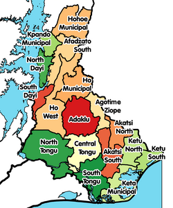
| Keta Municipal District | |
|---|---|
| Municipal District | |
 Districts of Volta Region Districts of Volta Region | |
 | |
| Coordinates: 5°54′11.16″N 0°59′12.48″E / 5.9031000°N 0.9868000°E / 5.9031000; 0.9868000 | |
| Country | |
| Region | |
| Capital | Keta |
| Government | |
| • Municipal Chief Executive | Hon. Sylvester Tornyeava |
| Area | |
| • Total | 182 km (70 sq mi) |
| Population | |
| • Total | 78,862 |
| • Density | 430/km (1,100/sq mi) |
| Time zone | UTC+0 (GMT) |
| ISO 3166 code | GH-TV-KA |
Keta Municipal District is one of the eighteen districts in Volta Region, Ghana. Originally created as an ordinary district assembly in 1988 when it was known as Keta District, which was created from the former Anlo District Council, until it was elevated to municipal district assembly status on 1 November 2007 (effectively 29 February 2008) to become Keta Municipal District. However on 19 February 2019, the western part of the district was split off to create Anloga District; thus the remaining part has been retained as Keta Municipal District. The municipality is located in the southeast part of Volta Region and has Keta as its capital town.
Boundaries
Keta Municipal District is bounded by:
- the Gulf of Guinea to the east and south,
- River Volta and South Tongu District to the west,
- Akatsi District to the north and northwest, and
- Ketu South Municipal District to the northeast.
Villages
In addition to Keta, the capital and administrative centre, Anloga (Angloga), Anyako and Abor are the only towns, Keta Municipal District contains the following villages:
- Abonokofe (village)
- Abor (town)
- Agbatsivi (village)
- Agobledokui (village)
- Agortoe (village)
- Agovinu (village)
- Akplorlortorkor (village)
- Anlo Afiadenyigba (village)
- Anloga (town)
- Anyako (town)
- Anyanui (village)
- Asadame (village)
- Atiavi (village)
- Atiteti / Antititi (village)
- Atito / Achito (village)
- Atorkor (village)
- Bomigo (village)
- Bleamezado (village)
- Dzelukope (village)
- Dzita (village)
- Dzita-Agbledomi (village)
- Fuveme (village)
- Galo-Sota (village)
- Gbetuinu (village)
- Hatorgodo (village)
- Horvi(village)
- Kedzi (village)
- Salo (village)
- Sasieme (village)
- Seva, Ghana|Seva (village)
- Srogbe (village)
- Tegbi (village)
- Trekume (village)
- Tregui (village)
- Tsiame (village)
- Tunu (village)
- Vodza (village)
- Weme (village)
- Woe (village)
- Wuti (village)
- Heluvi (Village)
Geography

Climate
Tropical savanna climates have monthly mean temperature above 18 °C (64 °F) in every month of the year and typically a pronounced dry season, with the driest month having precipitation less than 60mm (2.36 in) of precipitation. The Köppen Climate Classification subtype for this climate is "Aw". (Tropical Savanna Climate).
| Climate data for Keta Municipal District | |||||||||||||
|---|---|---|---|---|---|---|---|---|---|---|---|---|---|
| Month | Jan | Feb | Mar | Apr | May | Jun | Jul | Aug | Sep | Oct | Nov | Dec | Year |
| Mean daily maximum °C (°F) | 30 (86) |
31 (87) |
31 (88) |
31 (87) |
30 (86) |
29 (84) |
27 (81) |
27 (81) |
28 (83) |
29 (85) |
31 (88) |
31 (87) |
29 (85) |
| Mean daily minimum °C (°F) | 28 (82) |
29 (84) |
29 (84) |
29 (84) |
28 (82) |
27 (81) |
26 (78) |
25 (77) |
26 (79) |
27 (80) |
28 (82) |
28 (82) |
27 (81) |
| Average precipitation days | 0 | 0 | 2 | 3 | 4 | 6 | 3 | 2 | 5 | 4 | 1 | 1 | 31 |
| Source: Weatherbase | |||||||||||||
Sources
External links
References
- "GHANA: Administrative Division Regions and Districts". citypopulation.de. Archived from the original on 9 December 2024.
- "Keta Municipal District". keta.ghanadistricts.gov.gh. 2024. Retrieved 2024-05-21.
- "Volta » Keta Municipal". ghanadistricts.com. 22 May 2024. Archived from the original on 23 July 2011. Retrieved 22 May 2024.
- "Koppen Climate Classification (Weatherbase)". Weatherbase. 22 May 2024. Retrieved 22 May 2024.
- "Weatherbase.com". Weatherbase. 2013. Retrieved on May 11, 2013.
| Districts and Capitals of the Volta Region of Ghana | ||
|---|---|---|
| Municipal (6) |
|  |
| Ordinary (12) |
| |
5°54′11.16″N 0°59′12.48″E / 5.9031000°N 0.9868000°E / 5.9031000; 0.9868000
Category: