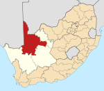
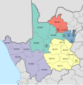
Local municipality in Northern Cape, South Africa
Kgatelopele Municipality (Afrikaans : Kgatelopele Munisipaliteit ; Tswana : Mmasepala wa Kgatelopele ) is a local municipality within the ZF Mgcawu District Municipality , in the Northern Cape province of South Africa . Kgatelopele is a Setswana name meaning "progress".
Main places
The 2001 census divided the municipality into the following main places :
Politics
Main article: Kgatelopele Local Municipality elections
The municipal council consists of eleven members elected by mixed-member proportional representation . Six councillors are elected by first-past-the-post voting in six wards , while the remaining five are chosen from party lists so that the total number of party representatives is proportional to the number of votes received. In the election of 1 November 2021 no party obtained a majority on the council. The following table shows the results of the election.
Kgatelopele local election, 1 November 2021
Party
Votes
Seats
Ward
List
Total
%
Ward
List
Total
African National Congress
1,939
2,006
3,945
43.7%
5
0
5
Patriotic Alliance
810
858
1,668
18.5%
0
2
2
Democratic Alliance
762
770
1,532
17.0%
1
1
2
Economic Freedom Fighters
384
442
826
9.1%
0
1
1
Freedom Front Plus
397
381
778
8.6%
0
1
1
Independent candidates
200
–
200
2.2%
0
–
0
Azanian People's Organisation
34
47
81
0.9%
0
0
0
Total
4,526 4,504 9,030 6 5 11
Valid votes
4,526
4,504
9,030
97.8%
Spoilt votes
89
117
206
2.2%
Total votes cast
4,615 4,621 9,236
Voter turnout
4,621
Registered voters
9,518
Turnout percentage
48.6%
'
References
"Contact list: Executive Mayors" . Government Communication & Information System. Archived from the original on 14 July 2010. Retrieved 22 February 2012.^ "Statistics by place" . Statistics South Africa. Retrieved 27 September 2015.
"Statistics by place" . Statistics South Africa. Retrieved 27 September 2015.South African Languages - Place names
Lookup Tables - Statistics South Africa
"Results Summary - All Ballots" (PDF). Electoral Commission of South Africa . 8 November 2021. Retrieved 12 November 2021."Seat Calculation Detail" (PDF). Electoral Commission of South Africa . 8 November 2021. Retrieved 12 November 2021.
External links
Category :
Text is available under the Creative Commons Attribution-ShareAlike License. Additional terms may apply.
**DISCLAIMER** We are not affiliated with Wikipedia, and Cloudflare.
The information presented on this site is for general informational purposes only and does not constitute medical advice.
You should always have a personal consultation with a healthcare professional before making changes to your diet, medication, or exercise routine.
AI helps with the correspondence in our chat.
We participate in an affiliate program. If you buy something through a link, we may earn a commission 💕
↑
 Seal
Seal Location in the Northern Cape
