You can help expand this article with text translated from the corresponding article in Arabic. (January 2021) Click for important translation instructions.
|
| Khachna Massif | |
|---|---|
| جبال الخشنة | |
| Highest point | |
| Peak | Bouzegza Mount [ar], Bouzegza Keddara |
| Elevation | 1,032 m (3,386 ft) |
| Geography | |
| Location | Kabylia |
| Country | |
| Regions | |
| Geology | |
| Formed by | Tell Atlas |
| Mountain type | Mountain range |
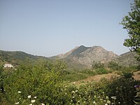
The Khachna Range (Arabic: جبال الخشنة, Jibal Khashna; Berber Adrar n Kheshna) is a mountain range of the Tell Atlas, part of the Atlas Mountain System. It is located in Kabylie, Algeria.
Geography
Main article: Geography of AlgeriaThe Khachna is a massif made up of two differentiated ranges, one in the north between Thénia and Zemmouri, and the other in the south between Thénia and Lakhdaria.
Its highest point, Bouzegza Mount known in Kabylian as Athrar Azegzaw, has an elevation of 1,083 metres (3,553 ft) and it is located in the southern subrange.
Other notable summits are the 710 m high Djerrah Mount, a peak located in the central area of the massif, a second highest point of the southern subrange.
Villages
This mountain range is home to dozens of villages including:
- A
- B
- C
- F
- L
- O
- T
Summits
Several mountain peaks are found in this mountain range:
- Bouzegza Mount [ar] (1032 m)
- Djerrah Mount (740 m)
- Ighil Zenabir Mount (630 m)
- Ben Norah Mount (467 m)
- Sidi Fredj Mount (452 m)
- Bouarous Mount (444 m)
- Soumâa Mount (430 m)
- Bouzareah Mountain (410m)
Forests

The plant cover in this mountain range shelters several forests including:
Rivers

This mountain range is crossed by dozens of rivers:
- Arbia River
- Boudouaou River [ar]
- Oued Boumerdès [ar]
- Oued Corso [ar]
- Hamiz River
- Isser River
- Keddache River
- Meraldene River
Dams

Several hydraulic dams have been built on the waterways of this mountain range:
Gallery
See also
- Kabyles
- Al-arbaâ Valley
- List of mountains in Algeria
- Tell Atlas
- Reghaïa Valley
- Corso Valley
- Boudouaou Valley
- Boumerdès Valley
- Arabeya Valley
References
- Hanoteau, Adolphe; Letourneux, Aristide Horace (1893). "La Kabylie et les coutumes kabyles".
- "Bulletin: Stratigraphie. 2. Sér". 1891.
- "Bulletin de la Société géologique de France".
- Ficheur, Louis Emile (1890). "Description géologique de la Kabylie du Djurjura: étude spéciale des terrains tertiaires".
- Duparc, Louis; Pearce, Francis Barrow; Ritter, Etienne (1900). "Les roches éruptives des environs de Ménerville (Algérie): Etude pétrographique".
- Lefebvre, Henri (1900). "Les forêts de l'Algérie".
- "Bulletin de la Société géologique de France".
- Ficheur (1890). "Les terrains éocènes de la Kabylie du Djurjura".
- Duparc, Louis; Pearce, Francis Barrow; Ritter, Etienne (1900). "Les roches éruptives des environs de Ménerville (Algérie): Etude pétrographique".
- "Bulletin de la Société géologique de France". 1899.
- France, Société Géologique de (1895). "Bulletin de la Société géologique de France".
| Tell Atlas | |
|---|---|
| Saharan Atlas | |
| Saharan massifs | |
| Peaks | |
This Algeria location article is a stub. You can help Misplaced Pages by expanding it. |
This article about a location in Boumerdès Province is a stub. You can help Misplaced Pages by expanding it. |
This article about a regional geological feature is a stub. You can help Misplaced Pages by expanding it. |


