Map all coordinates using OpenStreetMap
Download coordinates as:
Suburb of Shire of Banana, Queensland, Australia| Kianga Queensland | |||||||||||||||
|---|---|---|---|---|---|---|---|---|---|---|---|---|---|---|---|
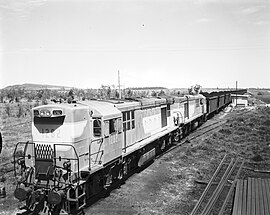
 Coal train, Moura mine, circa 1966 Coal train, Moura mine, circa 1966 | |||||||||||||||
 | |||||||||||||||
| Coordinates | 24°41′25″S 150°01′35″E / 24.6902°S 150.0263°E / -24.6902; 150.0263 (Kianga (centre of locality)) | ||||||||||||||
| Population | 219 (2021 census) | ||||||||||||||
| • Density | 0.5281/km (1.368/sq mi) | ||||||||||||||
| Postcode(s) | 4718 | ||||||||||||||
| Elevation | 100–280 m (328–919 ft) | ||||||||||||||
| Area | 414.7 km (160.1 sq mi) | ||||||||||||||
| Time zone | AEST (UTC+10:00) | ||||||||||||||
| Location | |||||||||||||||
| LGA(s) | Shire of Banana | ||||||||||||||
| State electorate(s) | Callide | ||||||||||||||
| Federal division(s) | Flynn | ||||||||||||||
| |||||||||||||||
Kianga is a rural locality in the Shire of Banana, Queensland, Australia. In the 2021 census, Kianga had a population of 219 people.
Geography
The land use is a mixture of mining, grazing on native vegetation, and crop growing.
There are a number of railway stations within the locality:
- on the Moura railway line (from west to east):
- Moura West railway station (24°32′58″S 150°00′14″E / 24.5495°S 150.0039°E / -24.5495; 150.0039 (Moura West railway station))
- Moura Mine railway station (24°31′36″S 150°03′59″E / 24.5267°S 150.0665°E / -24.5267; 150.0665 (Moura Mine railway station))
- on the closed Dawson Valley railway line with all stations now abandoned (from north to south):
- Gibihi railway station (24°36′55″S 149°59′52″E / 24.6153°S 149.9977°E / -24.6153; 149.9977 (Gibihi railway station))
- Kianga railway station (24°41′42″S 150°00′45″E / 24.6949°S 150.0124°E / -24.6949; 150.0124 (Kianga railway station))
- Nipan railway station (24°46′27″S 150°01′18″E / 24.7742°S 150.0217°E / -24.7742; 150.0217 (Nipan railway station))
- Willawa railway station (24°49′57″S 150°02′01″E / 24.8324°S 150.0337°E / -24.8324; 150.0337 (Willawa railway station))
- Kaloola railway station (24°50′55″S 150°03′45″E / 24.8487°S 150.0624°E / -24.8487; 150.0624 (Kaloola railway station))
History
The locality takes its name from the former railway station, named on 23 December 1937 by Queensland Railways Department after a pastoral run. It is an Aboriginal word, meaning home.
On 20 September 1975, there was an explosion in Kianga No. 1 underground coal mine resulting in the deaths of 13 miners. On 11 March 1978, a memorial centre in Moura (the nearest town) was officially opened to commemorate the disaster.
Demographics
In the 2016 census, Kianga had a population of 227 people.
In the 2021 census, Kianga had a population of 219 people.
Education
There are no schools in Kianga. The nearest government primary schools are Moura State School in neighbouring Moura to the north-west, Banana State School in neighbouring Banana to the north-east, and Theodore State School in Theodore to the south. The nearest government secondary schools are Moura State High School (to Year 12) in Moura and Theodore State School (to Year 10) in Theodore.
References
- ^ Australian Bureau of Statistics (28 June 2022). "Kianga (SAL)". 2021 Census QuickStats. Retrieved 28 February 2023.

- ^ "Queensland Globe". State of Queensland. Retrieved 1 October 2023.
- ^ "Kianga – locality in Shire of Banana (entry 49559)". Queensland Place Names. Queensland Government. Retrieved 25 October 2019.
- ^ "Railway stations and sidings - Queensland". Queensland Open Data. Queensland Government. 2 October 2020. Archived from the original on 5 October 2020. Retrieved 5 October 2020.
- "Kianga No. 1 Mine Explosion 1975". Mining Accident Database. Archived from the original on 23 March 2023. Retrieved 2 October 2023.
- "Kianga Memorial Centre". Monument Australia. Archived from the original on 2 October 2023. Retrieved 2 October 2023.
- Australian Bureau of Statistics (27 June 2017). "Kianga (SSC)". 2016 Census QuickStats. Retrieved 20 October 2018.

- "Layers: Locality; Schools and school catchments". Queensland Globe. Queensland Government. Archived from the original on 19 December 2017. Retrieved 1 October 2023.