| This article needs additional citations for verification. Please help improve this article by adding citations to reliable sources. Unsourced material may be challenged and removed. Find sources: "Kita-Kantō Expressway" – news · newspapers · books · scholar · JSTOR (April 2013) (Learn how and when to remove this message) |
 Kita-Kantō Expressway
 | |
|---|---|
| 北関東自動車道 | |
| Route information | |
| Length | 87.3 km (54.2 mi) |
| Existed | 2000–present |
| Major junctions | |
| From | Takasaki Junction in Takasaki, Gunma |
| To | Mito-minani Interchange in Mito, Ibaraki |
| Location | |
| Country | Japan |
| Major cities | Maebashi, Isesaki, Ōta, Shimotsuke, Utsunomiya, Mooka, Sakuragawa, Kasama |
| Highway system | |

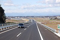
The Kita-Kantō Expressway (北関東自動車道, Kita-Kantō Jidōsha-dō) (lit. North Kantō Expressway) is a 4-laned national expressway in Japan. It is owned and operated by East Nippon Expressway Company.
Overview
The route connects the capitals of the three northern prefectures in the Kantō region: Maebashi, Utsunomiya, and Mito.
The expressway begins at a junction with the Kan-etsu Expressway in Gunma Prefecture and heads east along the southern edge of the prefecture. The route ends abruptly in the city of Ōta, however the route will be extended to a junction with the Tōhoku Expressway in Tochigi Prefecture by 2011. The expressway then follows the route of the Tōhoku Expressway northward for about 13 km, then diverges from this expressway following an easterly course once more. It runs through the southern areas of Utsunomiya and heads into eastern areas of Tochigi Prefecture, where the route terminates once again in the city of Mooka. The section connecting Tochigi and Ibaraki Prefectures was scheduled to be completed in 2009. From Sakuragawa in western Ibaraki, the route continues towards a junction with the Jōban Expressway and runs along the southern edge of the Mito city area, where the expressway has its final terminus. At the terminus, the Higashi-Mito Road continues towards the Pacific Ocean coastline using the same roadway.
The route runs parallel to National Route 50 for most of its length.
List of interchanges and features
- IC - interchange, SIC - smart interchange, JCT - junction, SA - service area, PA - parking area, BR - bridge
| Prefecture | Location | km | mi | Exit | Name | Destinations | Notes |
|---|---|---|---|---|---|---|---|
| Gunma | Takasaki | 0.0 | 0.0 | 9-2 | Takasaki JCT | Roadway continues as Kan-etsu Expressway | |
| Tonegawa Bridge over the Tone River | |||||||
| Maebashi | 3 | 1.9 | 1 | Maebashi-minami IC | |||
| 7.5 | 4.7 | 2 | Komagawa IC | ||||
| Isesaki | 11.7 | 7.3 | 2-1 PA | Hashie PA/SIC | Convenience store attached | ||
| 14.5 | 9.0 | 3 | Isesaki IC | ||||
| Ōta | 19.9 | 12.4 | 4 | Ōta-Yabuzuka IC | |||
| 26.6 | 16.5 | 4-1 PA | Ōta-Gōdo PA/SIC | Gas station attached | |||
| 30.5 | 19.0 | 5 | Ōta-Kiryū IC | ||||
| Tochigi | Ashikaga | 34.3 | 21.3 | - | Ashikaga SIC | Scheduled to open in 2028 | |
| 40.8 | 25.4 | 6 | Ashikaga IC | ||||
| 47 | 29 | 6-1 PA | Izuruhara PA/SIC | ||||
| Sano | 49.1 | 30.5 | 7 | Sano-Tanuma IC | |||
| Tochigi | 54.4 | 33.8 | 7-1 | Iwafune JCT | |||
| 68 | 42 | 8-1 | Tochigi-Tsuga JCT | ||||
| 71.8 | 44.6 | 8 | Tsuga IC | ||||
| Mibu | 76.6 | 47.6 | PA | Mibu PA | |||
| 78.1 | 48.5 | 9 | Mibu IC | Hanyūda Kamikamou Route | |||
| Shimotsuke | 82.3 | 51.1 | - | Shimotsuke SIC | Expected to open FY2025 | ||
| Utsunomiya | 86.5 | 53.7 | 10 | Utsunomiya-Kaminokawa IC | |||
| Mooka | 94.2 | 58.5 | 11 | Mooka IC | |||
| - | Gogyo River PA | (Provisional name) | |||||
| Ibaraki | Sakuragawa | 108.9 | 67.7 | 12 | Sakuragawa-Chikusei IC | ||
| Kasama | 117.8 | 73.2 | 13 | Kasama-nishi IC | Tsuchiura Kasama Route Bypass | ||
| 125.5 | 78.0 | PA | Kasama PA/SIC | ||||
| 126.9 | 78.9 | 14 | Tomobe IC | ||||
| 134.3 | 83.5 | 8-2 | Tomobe JCT | ||||
| Ibaraki | 138.4 | 86.0 | 15 | Ibarakimachi-nishi IC | |||
| 140.6 | 87.4 | 15-1 | Ibaraki JCT | ||||
| 145.2 | 90.2 | 16 | Ibarakimachi-higashi IC | ||||
| Mito | 148.6 | 92.3 | 17 | Mito-minami IC | |||
| Through to | |||||||
1.000 mi = 1.609 km; 1.000 km = 0.621 mi
| |||||||
References
- "Ibaraki Prefecture Website". Archived from the original on 2008-04-20. Retrieved 2008-04-15.
- "E-NEXCO Expressway Data". Archived from the original on 2007-12-13. Retrieved 2008-04-13.
- ^ "E-NEXCO Opening Schedule". Archived from the original on 2007-10-16. Retrieved 2008-04-15.
External links
- (in Japanese) East Nippon Expressway Company
- (in Japanese) Ibaraki Kitakan (info page by Ibaraki Prefectural Government)
Categories: