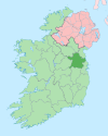
Village in Leinster, Ireland
| Knightsbrook | |
|---|---|
| Village | |
 | |
| Coordinates: 53°31′55″N 6°47′13″W / 53.531852°N 6.786913°W / 53.531852; -6.786913 | |
| Country | Ireland |
| Province | Leinster |
| County | County Meath |
| Time zone | UTC+0 (WET) |
| • Summer (DST) | UTC-1 (IST (WEST)) |
Knightsbrook is a village and townland in County Meath, Ireland. It is located on the R158 road, close to the junction with the R159. to the south of Trim.
The town is located in the civil parish of Laracor. Knightsbrook Hotel and Golf Club stands to the north, and the Knightsbrook River flows through the south of the townland.
See also
References
- "Knightsbrook Townland, Co. Meath". www.townlands.ie. Retrieved 8 July 2020.
- "Knightsbrook". Logainm.ie. Retrieved 8 July 2020.
- "Relation: Knightsbrook (4551683)". OpenStreetMap. Retrieved 8 July 2020.
This article related to the geography of County Meath, Ireland is a stub. You can help Misplaced Pages by expanding it. |
