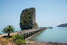
Ko Sarai (Thai: เกาะสาหร่าย, pronounced [kɔ̀ʔ sǎːràːj]) is a subdistrict (tambon) in Mueang Satun District, Satun Province, Thailand. It is composed of 3 island groups, totaling 243 km, and has a population of 5077 as of 2012 .
- The biggest village is Ban Ko Sarai (sometimes called Ban Yaratot Yai), on the island with the same name.
- The population relies on fishing, agriculture and tourism.
- Amongst the attractions, Ko Tarutao, Ko Lipe, Ko Adang.
Table of islands
| Nr | Island | Capital | Other Cities | Area (km) | Population |
|---|---|---|---|---|---|
| 1 | Mu Ko Adang – Rawi | Ao Sunrise | Ao Sunset, Ko Adang, Ko Rawi | 67 | 1210 |
| 2 | Mu Ko Sarai | Yaratot Yai | Yaratot Noi, Bakan Tohin, BaKan Yai, | 13 | 3850 |
| 3 | Mu Ko Tarutao | Ao Phante Malaka | Ao Chak, Ao Mo Lae, Ao Talo Udang, Ao Talo Wao, | 163 | 20 |
| Ko Sarai Tambon | Yaratot Yai | Ko Lipe | 243 | 5077 |
See also
Notes
- The Islands area and population data retrieved from the 2012 census
References
6°35′N 99°31′E / 6.583°N 99.517°E / 6.583; 99.517
This Satun Province location article is a stub. You can help Misplaced Pages by expanding it. |