| Kokubunji 国分寺市 | |
|---|---|
| City | |
 Kokubunji City Hall Kokubunji City Hall | |
 Flag Flag Seal Seal | |
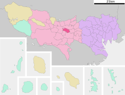
 Location of Kokubunji in Tokyo Location of Kokubunji in Tokyo | |
 | |
| Coordinates: 35°42′39.4″N 139°27′43.8″E / 35.710944°N 139.462167°E / 35.710944; 139.462167 | |
| Country | Japan |
| Region | Kantō |
| Prefecture | Tokyo |
| First official recorded | 741 AD (official) |
| Town settled | December 11, 1940 |
| City settled | November 3, 1964 |
| Government | |
| • Mayor | Kunio Izawa (since July 2013) |
| Area | |
| • Total | 11.46 km (4.42 sq mi) |
| Population | |
| • Total | 126,791 |
| • Density | 11,000/km (29,000/sq mi) |
| Time zone | UTC+9 (Japan Standard Time) |
| Symbols | |
| • Tree | Zelkova serrata |
| • Flower | Satsuki azalea |
| Phone number | 042-325-0111 |
| Address | 1-6-1 Tokura, Kokubunji-shi, Tokyo 185-8501 |
| Website | Official website |

Kokubunji (国分寺市, Kokubunji-shi) is a city located in the western portion of the Tokyo Metropolis, Japan. As of 1 March 2021, the city had an estimated population of 126,791, and a population density of 11,000 persons per km. The total area of the city was 11.46 square kilometres (4.42 sq mi).
Geography
Kokubunji is located on the Musashino Terrace of western Tokyo, approximately in the geographic centre of mainland Tokyo Metropolis. The city extends for about 5.68 kilometers east-to-west by about 3.86 kilometers north-to-south.
Surrounding municipalities
Climate
Kokubunji has a humid subtropical climate (Köppen Cfa) characterized by warm summers and cool winters with light to no snowfall. The average annual temperature in Kokubunji is 14.0 °C. The average annual rainfall is 1647 mm, with September as the wettest month. The temperatures are highest on average in August (at around 25.5 °C) and lowest in January (at around 2.6 °C).
Demographics
Per Japanese census data, the population of Kokubunji increased rapidly in the 1950s and 1960s and has continued to grow at a slower rate since then.
| Year | Pop. | ±% |
|---|---|---|
| 1920 | 4,618 | — |
| 1930 | 6,454 | +39.8% |
| 1940 | 9,324 | +44.5% |
| 1950 | 19,125 | +105.1% |
| 1960 | 39,098 | +104.4% |
| 1970 | 81,259 | +107.8% |
| 1980 | 91,010 | +12.0% |
| 1990 | 100,982 | +11.0% |
| 2000 | 111,404 | +10.3% |
| 2010 | 120,650 | +8.3% |
| 2020 | 129,242 | +7.1% |
History
The area of present-day Kokubunji was part of ancient Musashi Province, and was the site of the Nara period Provincial temple of that province. In the post-Meiji Restoration cadastral reform of 1878, the area became part of Kitatama District in Kanagawa Prefecture. The village of Kokubunji was created on April 1, 1889, with the establishment of the modern municipalities system. Kitatama District was transferred to the administrative control of Tokyo Metropolis on April 1, 1893. Kokubunji was elevated to town status in 1940, and to city status on November 3, 1964.
Government
Kokubunji has a mayor-council form of government with a directly elected mayor and a unicameral city council of 22 members. Kokubunji, together with the city of Kunitachi, contributes two members to the Tokyo Metropolitan Assembly. In terms of national politics, the city is part of Tokyo 19th district of the lower house of the Diet of Japan.
Economy
Kokubunji is the home of the Hitachi Central Research Laboratory, which contains one of the largest natural preserves in the area surrounding Tokyo. The Railway Technical Research Institute, the technical research company under the Japan Railways group of companies is also located in Kokubunji.
Education
The city has one public high school, Kokubunji High School [ja], which is operated by the Tokyo Metropolitan Government Board of Education.
Kokubunji has ten public elementary schools and five public middle schools.
Municipal junior high schools:
Municipal elementary schools:
- No. 1 (第一小学校)
- No. 2 (第二小学校)
- No. 3 (第三小学校)
- No. 4 (第四小学校)
- No. 5 (第五小学校)
- No. 6 (第六小学校)
- No. 7 (第七小学校)
- No. 8 (第八小学校)
- No. 9 (第九小学校)
- No. 10 (第十小学校)
There is also one private K-12 school, affiliated with Waseda University: Waseda Jitsugyo Primary, Junior High, and Senior High School [ja].
Tokyo Keizai University has a campus at Kokubunji.
Transportation
Railway
- Nishi-Kokubunji
![]() Seibu Railway - Seibu Kokubunji Line
Seibu Railway - Seibu Kokubunji Line
![]() Seibu Railway - Seibu Tamako Line
Seibu Railway - Seibu Tamako Line
- Kokubunji
Highway
- Kokubunji is not served by any national highways or expressways.
Sister cities
 Marion, South Australia, Australia
Local attractions
- Site of Musashi kokubunji
- Tonogayato Garden
References
- "Kokubunji city official statistics" (in Japanese). Japan.
- Kokubunji climate data
- Kokubunji population statistics
- Hitachi Central Research Laboratory website Archived 2016-03-04 at the Wayback Machine, retrieved 28 January 2013
- Tokyo Metropolitan Kokubunji High School website Archived 2020-11-01 at the Wayback Machine, retrieved 23 June 2008
- "Compulsory Education Systems in Japan", Kokubunji official website Archived 2007-08-13 at the Wayback Machine, retrieved 23 June 2008
- "各中学校の紹介". Kokubunji City. Retrieved 2022-12-04.
- "各小学校の紹介". Kokubunji City. Retrieved 2022-12-04.
- "International Exchange". List of Affiliation Partners within Prefectures. Council of Local Authorities for International Relations (CLAIR). Archived from the original on 5 March 2016. Retrieved 21 November 2015.
External links
 Media related to Kokubunji, Tokyo at Wikimedia Commons
- Kokubunji City Official Website (in Japanese)
| Tokyo Metropolis | |||||||||
|---|---|---|---|---|---|---|---|---|---|
| Special Wards of Tokyo | |||||||||
| Western (Tama area) |
| ||||||||
| Insular Area |
| ||||||||