| Kozina | |
|---|---|
 | |
 | |
| Coordinates: 45°36′32.8″N 13°56′11.57″E / 45.609111°N 13.9365472°E / 45.609111; 13.9365472 | |
| Country | |
| Traditional region | Littoral |
| Statistical region | Coastal–Karst |
| Municipality | Hrpelje-Kozina |
| Area | |
| • Total | 2.96 km (1.14 sq mi) |
| Elevation | 492.7 m (1,616.5 ft) |
| Population | |
| • Total | 664 |
Kozina (pronounced [kɔˈziːna] ; Italian: Cosina) is a settlement in the Municipality of Hrpelje-Kozina in the Littoral region of Slovenia, close to the border with Italy.
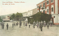
The village developed only after the railway was established; in 1825 there were only three houses in Kozina. It became an important center for teamsters, with twelve inns with stalls for teamsters' horses. Today it lies at the intersection of the A1 motorway (Ljubljana–Koper) with Route 7 (Trieste–Rijeka).

References
- Statistical Office of the Republic of Slovenia. stat.si
- Hrpelje-Kozina municipal site Archived 2008-12-18 at the Wayback Machine. hrpelje-kozina.si
- Savnik, Roman (1968). Krajevni leksikon Slovenije, vol. 1. Ljubljana: Državna založba Slovenije. p. 318.
External links
 Media related to Kozina at Wikimedia Commons
- Kozina on Geopedia
This article about the Municipality of Hrpelje-Kozina in Slovenia is a stub. You can help Misplaced Pages by expanding it. |
