| Królewo | |
|---|---|
| Village | |
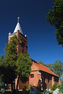
 Saint Nicholas church in Królewo Saint Nicholas church in Królewo | |
 | |
| Coordinates: 54°2′29″N 19°8′29″E / 54.04139°N 19.14139°E / 54.04139; 19.14139 | |
| Country | |
| Voivodeship | Pomeranian |
| County | Malbork |
| Gmina | Stare Pole |
| Population | 382 |
| Time zone | UTC+1 (CET) |
| • Summer (DST) | UTC+2 (CEST) |
| Vehicle registration | GMB |
Królewo is a village in the administrative district of Gmina Stare Pole, within Malbork County, Pomeranian Voivodeship, in northern Poland. It lies approximately 5 kilometres (3 mi) west of Stare Pole, 8 km (5 mi) east of Malbork, and 49 km (30 mi) south-east of the regional capital Gdańsk.
History
The village was part of Poland until 1772, when it was annexed by Prussia in the First Partition of Poland, from 1871 to 1945 it was part of Germany. During World War II, the Germans established and operated a forced labour subcamp of the German military prison in Grudziądz in German-occupied Poland. After Germany's defeat in the war in 1945 the village was restored to Poland.
References
- "Central Statistical Office (GUS) - TERYT (National Register of Territorial Land Apportionment Journal)" (in Polish). 2008-06-01.
- Jan Daniluk, Wykorzystanie siły roboczej jeńców wojennych w XX Okręgu Wojskowym w latach II wojny światowej (zarys problemu), "Łambinowicki rocznik muzealny" Tom 35, Opole, 2012, p. 28 (in Polish)
| Gmina Stare Pole | ||
|---|---|---|
| Seat |  | |
| Other villages | ||
This Malbork County location article is a stub. You can help Misplaced Pages by expanding it. |