| Krobica | |
|---|---|
| Village | |
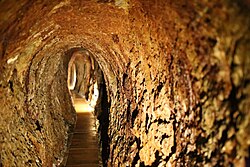
 Underground tourist route in a former tin and cobalt mine Underground tourist route in a former tin and cobalt mine | |
 | |
| Coordinates: 50°55′40″N 15°21′08″E / 50.92778°N 15.35222°E / 50.92778; 15.35222 | |
| Country | |
| Voivodeship | Lower Silesian |
| County | Lwówek Śląski |
| Gmina | Mirsk |
| Highest elevation | 460 m (1,510 ft) |
| Lowest elevation | 400 m (1,300 ft) |
| Population | |
| • Total | 360 |
| Time zone | UTC+1 (CET) |
| • Summer (DST) | UTC+2 (CEST) |
| Vehicle registration | DLW |
Krobica is a village in the administrative district of Gmina Mirsk, within Lwówek Śląski County, Lower Silesian Voivodeship, in south-western Poland, close to the Czech border.
It lies approximately 6 kilometres (4 mi) south-west of Mirsk, 27 kilometres (17 mi) south-west of Lwówek Śląski, and 121 kilometres (75 mi) west of the regional capital Wrocław.
There is an underground tourist route in the former tin and cobalt mine.
A trade route connecting Jelenia Góra with Frýdlant and Zittau passed through the village in the late medieval and early modern periods.
References
- "Central Statistical Office (GUS) – TERYT (National Register of Territorial Land Apportionment Journal)" (in Polish). 2008-06-01.
- Boguszewicz, Artur (2010). Corona Silesiae (in Polish). Wrocław: Wydział Nauk Historycznych i Pedagogicznych Uniwersytetu Wrocławskiego. p. 43. ISBN 978-83-922130-8-6.
| Gmina Mirsk | ||
|---|---|---|
| Town and seat |  | |
| Villages | ||
This Lwówek Śląski County location article is a stub. You can help Misplaced Pages by expanding it. |