This article has multiple issues. Please help improve it or discuss these issues on the talk page. (Learn how and when to remove these messages)
|
| Kurram | |
|---|---|
 | |
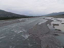
 Course of the Kurrama River Course of the Kurrama River | |
| Native name | د کورمې سيند (Pashto) |
| Location | |
| Country | Pakistan |
| Province | Khyber Pakhtunkhwa |
| Region | Kurram Agency |
| Physical characteristics | |
| Source | |
| • location | 20 km (12 mi) southeast of Gardez, Paktia |
| Mouth | Indus River |
| • location | near Isa Khel |
| • coordinates | 32°37′36″N 71°21′53″E / 32.6267°N 71.3648°E / 32.6267; 71.3648 |
| Length | 320 km (200 mi) |
| Basin features | |
| Tributaries | |
| • right | Gambila |
The Kurram River (Pashto: د کورمې سيند), or Kurrama River, originates from the watershed of Spin Ghar region in the Paktia province of Afghanistan and the Kurram District of Pakistan. It flows through North Waziristan, and the city of Bannu, before joining the Indus River near Isa Khel. It drains the southern flanks of the Spin Ghar mountain range and is a right-bank tributary of the Indus.
Kurram River mainly passes through the southern Tribal Areas of Khyber Pakhtunkhwa. It irrigates around 32,000 hectares (80,000 acres) of land.
Its tributaries include the Kirman and the Khurmana rivers.
The nearby Kurran-Garhi Project, finished in 1962, provides flood control and is used for irrigation and power. The soil around Kurram river is very suitable for agriculture. It contains living properties and is subject to flood in some season.
Topography
Generally, the topography of the catchment area of the Kurram River is mountainous in the upper reaches near Ali Khayl, Mirazi Kalay, Peer Kalai, Kharlachi, Parachinar and Thal areas. Near Bannu city, the river flattens up and follows a consistent mild slope up to its outfall in to the Indus River near Isa Khel. The elevations ranging from about 4750 m to 200 m and sloping northwest–southeast. Most of the flat terraces available along the river are utilized for agriculture for which water from the river is utilised. Moreover, there exist a number of irrigation canals and civil channels on overtaking from the river.
See also
References
- Ali, Fawad (September 21, 2016). "Pakistani officials call for water agreement with Afghanistan". The Third Pole. Retrieved 2020-07-27.
- Ali, Zulfiqar (6 June 2005). "Topographic survey of Kurram river planned". DAWN.COM. Retrieved 13 May 2018.
- "Geography". FATA - Official Web Portal. Archived from the original on 13 May 2018. Retrieved 13 May 2018.
- "Bannu". britannica.com.
- Ullah, Atta; Wazir, Sultan Mehmood; Farooq, Ayesha; Muhammad, Asim; Latif, Abdul; Muhammad, Shah Faisal (2011-06-30). "Soil Features of Kurram River Beds of District Bannu, Pakistan". Pakistan Journal of Plant Sciences. 16–17 (2–1).
| Khost Province | ||
|---|---|---|
| Capital: Khost | ||
| Districts |  | |
| Populated places | ||
| Landforms | ||
| Other | ||
This article related to a river in Pakistan is a stub. You can help Misplaced Pages by expanding it. |