| Kumluca | |
|---|---|
| District and municipality | |
 Aerial view Aerial view | |
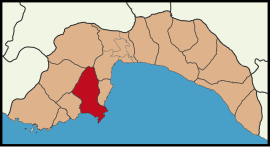
 Map showing Kumluca District in Antalya Province Map showing Kumluca District in Antalya Province | |
 | |
| Coordinates: 36°22′N 30°17′E / 36.367°N 30.283°E / 36.367; 30.283 | |
| Country | Turkey |
| Province | Antalya |
| Government | |
| • Mayor | Mesut Avcıoğlu (DP) |
| Area | 1,225 km (473 sq mi) |
| Elevation | 15 m (49 ft) |
| Population | 73,496 |
| • Density | 60/km (160/sq mi) |
| Time zone | UTC+3 (TRT) |
| Postal code | 07350 |
| Area code | 0242 |
| Website | www |
Kumluca is a municipality and district of Antalya Province, Turkey. Its area is 1,225 km, and its population is 73,496 (2022). It lies on the Mediterranean coast, and is part of the Turkish Riviera. Kumluca is located 90 km (56 mi) west of the city of Antalya, on the Teke Peninsula, (between the bays of Antalya and Fethiye). Its neighbour towns are Korkuteli, Elmalı, Finike, Kemer and Antalya
The town of Kumluca, formerly the village of Sarıkavak, is named for its sandy soil (kum meaning sand in Turkish), good for growing watermelons.
Geography
The centre of the district is a plain pointing north from the Mediterranean coast and surrounded by mountains on three sides. The northern part of the district is hilly and mountainous. Summers are hot and dry, winters cool and wet as one would expect in a Mediterranean district. The coast never gets snow, though it snows in the mountains. In this climate fruit and vegetables can be grown under glass all year round and this is the mainstay of the local economy, along with orange trees. Kumluca is a wealthy district.
Composition
There are 41 neighbourhoods in Kumluca District:
- Adrasan
- Altınyaka
- Bağlık
- Belen
- Beşikçi
- Beykonak
- Büyükalan
- Çaltı
- Çayiçi
- Cumhuriyet
- Dereköy
- Ellinci Yıl
- Erentepe
- Eskicami
- Göksu
- Gölcük
- Güzören
- Hacıveliler
- Hızırkahya
- İncircik
- Karacaağaç
- Karacaören
- Karşıyaka
- Kasapçayırı
- Kavakköy
- Kum
- Kuzca
- Mavikent
- Merkez
- Meydan
- Narenciye
- Ortaköy
- Salur
- Sarıcasu
- Sarıkavak
- Temel Eğitim
- Toptaş
- Yazır
- Yeni
- Yenikışla
- Yeşilköy
History
In the last years of the Seljuqs of Rum, silver coins were minted in the town. Between 1282 and 1302, the town struck dirhams under Kaykhusraw III, Kayqubad III, and Mesud II with the mint name Sarıkavak (Arabic: ساروقواق, Sārūqawāq)
Archaeologists have found a shipwreck dating back to the 15th-16th B.C 50 meters away from the coast of Kumluca district in early April in 2019. Archaeologist Hakan Öniz has published an article about this research in the journal Palestine Exploration Quarterly. He announced that a new Bronze Age shipwreck had been discovered in the same coast where the Gelidoniya and Uluburun shipwrecks were found and this finding belongs to earlier times than both of them.
Greek Families lived in the village together with the Turks of the village. The Greek families left during the Greek-Turkish population exchange.
Demographics
The district has a population of 73,496 (2022). The town itself has 42,861 inhabitants.
Tourism
There are a number of important historical sites in the district of Kumluca including Olympos, Kitanaura, Korydalla, Rhodiapolis, Idebessos and Gagai; of these Olympos is the largest and attracts the most visitors.
There is 30 km (19 mi) of coast with many hotels and restaurants between the villages of Adrasan and Olympos, and holiday villages near the town of Mavikent. West of Mavikent there is less development but taken as a whole Kumluca is one of the fastest growing local economies in Turkey.
References
- ^ "Address-based population registration system (ADNKS) results dated 31 December 2022, Favorite Reports" (XLS). TÜİK. Retrieved 22 May 2023.
- Büyükşehir İlçe Belediyesi, Turkey Civil Administration Departments Inventory. Retrieved 8 June 2023.
- "İl ve İlçe Yüz ölçümleri". General Directorate of Mapping. Retrieved 22 May 2023.
- Mahalle, Turkey Civil Administration Departments Inventory. Retrieved 22 May 2023.
- Diler, Ömer; Hinrichs, Johann-Christoph (2009), Islamic Mints (İslam darp yerleri), vol. 2, Istanbul: Spink, pp. 644–645, ISBN 978-975-8428-18-2
- "Copper Ingots Found in Ancient Shipwreck off Turkish Coast". Biblical Archaeology Society. 2019-04-18. Retrieved 2019-05-09.
- Öniz, Hakan (2019). "A new Bronze Age shipwreck with ingots in the west of Antalya—preliminary results". Palestine Exploration Quarterly. 151: 3–14. doi:10.1080/00310328.2019.1579467. S2CID 166861964.
- "Kumluca". citypopulation.de. Retrieved 19 June 2023.
External links
- District governor's official website (in Turkish)
- District municipality's official website (in Turkish)
- Information on Kumluca
| Kumluca in Antalya Province of Turkey | ||
|---|---|---|
| Districts |  | |
| Metropolitan municipalities are bolded. | ||
| Neighbourhoods of Kumluca District | |
|---|---|
|
