| Lübbenau/Spreewald | |
|---|---|
| Town | |
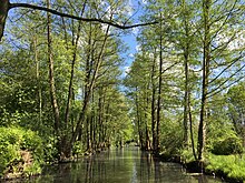
 Typical view in Lübbenau-Lehde Typical view in Lübbenau-Lehde | |
 Coat of arms Coat of arms | |
Location of Lübbenau/Spreewald within Oberspreewald-Lausitz district
 | |
  | |
| Coordinates: 51°52′N 13°58′E / 51.867°N 13.967°E / 51.867; 13.967 | |
| Country | Germany |
| State | Brandenburg |
| District | Oberspreewald-Lausitz |
| Government | |
| • Mayor (2024–32) | Helmut Wenzel (Ind.) |
| Area | |
| • Total | 138.78 km (53.58 sq mi) |
| Elevation | 52 m (171 ft) |
| Population | |
| • Total | 15,726 |
| • Density | 110/km (290/sq mi) |
| Time zone | UTC+01:00 (CET) |
| • Summer (DST) | UTC+02:00 (CEST) |
| Postal codes | 03222 |
| Dialling codes | 03542 |
| Vehicle registration | OSL, CA, SFB |
| Website | www.luebbenau-spreewald.de |
Lübbenau (German pronunciation: [lʏbəˈnaʊ], Lower Sorbian: Lubnjow [ˈlubnʲɔw]; officially Lübbenau/Spreewald, L.S. Lubnjow/Błota [ˈbwɔta] (meaning Lübbenau/Spree Forest)) is a town in the Upper Spree Forest-Lusatia District of Brandenburg, Germany. It is located in the bilingual German/Sorbian region of (Lower) Lusatia, on the river Spree, where this forms a large inland delta surrounded by woodland, called "Spree Forest", about 82 km (51 mi) southeast of Berlin. The town is best known through the incorporated villages of Lehde/Lědy and Leipe/Lipje, villages where there just exist anabranches of the Spree River instead of streets.
Administration
The town of Lübbenau consists of (German/Lower Sorbian):
- Lübbenau/Spreewald (Lubnjow/Błota) with Kaupen (Kupy), Neustadt (Nowe Město), Stennewitz (Sćenojce), Stottoff (Štotup), and Wotschofska (Wótšowska)
and the incorporated villages of:
- Bischdorf (Wótšowc)
- Boblitz (Bobolce)
- Groß Beuchow (Buchow) with Klein Beuchow (Buchojc)
- Groß Klessow (Klěšow) with Klein Klessow (Klěšojc) and Redlitz (Rědłojce)
- Groß Lübbenau (Lubń) with Scheddis (Pśedejs)
- Hindenberg (Želnjojce)
- Klein Radden (Radyńc) with Groß Radden (Radyń)
- Kittlitz (Dłopje) with Eisdorf (Stańšojce), Lichtenau (Lichtnow), and Schönfeld (Tłukom)
- Krimnitz (Kśimnice)
- Lehde (Lědy) with Dolzke (Dolck)
- Leipe (Lipje) with Dubkowmühle (Dubkowy Młyn), Eiche (Duby), Konzaks Horst (Kóńcakojc Wótšow), and Pohlenzschänke (Póleńcowa Kjarcma)
- Ragow (Rogow)
- Zerkwitz (Cerkwica)
History
Lübbenau was first mentioned in a sales document in 1315 but is believed to be much older due to excavations below the castle that show settlement from the 8th or 9th century.
From 1364 to 1635, Lübbenau was part of the Kingdom of Bohemia, and then until 1815 Lübbenau was a part of the Electorate of Saxony. From 1815 to 1947, Lübbenau was part of the Prussian Province of Brandenburg. From 1952 to 1990, it was part of the Bezirk Cottbus of East Germany.
Demography
-
 Development of population since 1875 within the current Boundaries (Blue Line: Population; Dotted Line: Comparison to Population development in Brandenburg state; Grey Background: Time of Nazi Germany; Red Background: Time of communist East Germany)
-
 Recent Population Development and Projections (Population Development before Census 2011 (blue line); Recent Population Development according to the Census in Germany in 2011 (blue bordered line); Official projections for 2005–2030 (yellow line); for 2017–2030 (scarlet line); for 2020–2030 (green line)
|
|
|
Sights

Lübbenau offers a variety of sights. Departing from the old town center, visitors can explore the marina with its traditional boats, or a castle which set in a nicely arranged park, including an orangerie with a cafe and a hotel. There are cycling routes to nearby villages, and boat rides are popular with tourists. The city wall's history dates back to the Middle Ages and the museum next to the city gate offers insights into the architecture as well as the rich history of the region.
Twin towns – sister cities
See also: List of twin towns and sister cities in GermanyLübbenau is twinned with:
 Halluin, France
 Kočevje, Slovenia
 Nowogród Bobrzański, Poland
 Oer-Erkenschwick, Germany
 Pniewy, Poland
 Świdnica, Poland
Notable people

- Romy Müller (born 1958), track and field athlete and Olympic champion
- Jens Riewa (born 1963), presenter and newscaster of the Tagesschau
Associated with the town
- Ehm Welk (1884–1966), writer, lived for a time in Lübbenau
- Nico (1938–1988), civil Christa Päffgen, model and singer, lived as a child in Lübbenau
- Marc Huster (born 1970), weight lifter, grew up in Lübbenau
References
- Landkreis Oberspreewald-Lausitz Wahl der Bürgermeisterin / des Bürgermeisters. Retrieved 3 July 2024.
- "Bevölkerungsentwicklung und Bevölkerungsstandim Land Brandenburg Dezember 2022" (PDF). Amt für Statistik Berlin-Brandenburg (in German). June 2023.
- Detailed data sources are to be found in the Wikimedia Commons.Population Projection Brandenburg at Wikimedia Commons
- "Städtepartnerschaft". luebbenau-spreewald.de (in German). Lübbenau/Spreewald. Retrieved 2021-02-19.
External links
![]() Media related to Lübbenau at Wikimedia Commons
Media related to Lübbenau at Wikimedia Commons
| Towns and municipalities in Oberspreewald-Lausitz | ||
|---|---|---|
