| La Faloise | |
|---|---|
| Commune | |
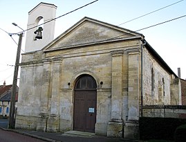
 The church in La Faloise The church in La Faloise | |
| Location of La Faloise | |
  | |
| Coordinates: 49°42′00″N 2°20′30″E / 49.7°N 2.3417°E / 49.7; 2.3417 | |
| Country | France |
| Region | Hauts-de-France |
| Department | Somme |
| Arrondissement | Montdidier |
| Canton | Ailly-sur-Noye |
| Intercommunality | CC Avre Luce Noye |
| Government | |
| • Mayor (2022–2026) | Cédric Boquet |
| Area | 9.75 km (3.76 sq mi) |
| Population | 215 |
| • Density | 22/km (57/sq mi) |
| Time zone | UTC+01:00 (CET) |
| • Summer (DST) | UTC+02:00 (CEST) |
| INSEE/Postal code | 80299 /80250 |
| Elevation | 57–158 m (187–518 ft) (avg. 84 m or 276 ft) |
| French Land Register data, which excludes lakes, ponds, glaciers > 1 km (0.386 sq mi or 247 acres) and river estuaries. | |
La Faloise (French pronunciation: [la falwaz]; Picard: Faloèse ) is a commune in the Somme department in Hauts-de-France in northern France.
Geography
La Faloise is situated on the D193 road, on the banks of the river Noye, some 15 miles (24 km) south of Amiens. La Faloise station has rail connections to Amiens and Creil.
History
La Faloise grew around a 13th-century château, which was ransacked in 1358, and then rebuilt early in the 15th century by the Burgundians. It was attacked by the English and taken in 1442. The chateau returned to the Burgundians under Charles le Téméraire, on return from his defeat at Beauvais. When he died in 1477, the towns of the Somme reverted to the French crown. La Faloise was then in the hands of the Montmorency family, seigneurs of Breteuil.
In the middle of the 15th century, Louis I de Bourbon married Eléonore of Roye and became seigneur of La Faloise. By the end of the century, the village had experienced much upheaval, being taken by the Ligueurs, Royalist, and then the Spanish. To complete the misfortune, the population was decimated by the plague in 1668.
The French Revolution saw La Faloise rebuilt and industrialised. It became famous for the fabrication of nails. This prosperity lasted until about 1850. The village was occupied by the Germans during the conflicts of the Franco-Prussian War of 1870, the First World War and the Second World War. The church burnt down in 1940; it was rebuilt after the Second World War.
Population
| Year | Pop. | ±% p.a. |
|---|---|---|
| 1968 | 248 | — |
| 1975 | 207 | −2.55% |
| 1982 | 184 | −1.67% |
| 1990 | 210 | +1.67% |
| 1999 | 210 | +0.00% |
| 2007 | 239 | +1.63% |
| 2012 | 213 | −2.28% |
| 2017 | 231 | +1.64% |
| Source: INSEE | ||
See also
References
- "Répertoire national des élus: les maires" (in French). data.gouv.fr, Plateforme ouverte des données publiques françaises. 13 September 2022.
- "Populations de référence 2022" (in French). The National Institute of Statistics and Economic Studies. 19 December 2024.
- Population en historique depuis 1968, INSEE
This Arrondissement of Montdidier geographical article is a stub. You can help Misplaced Pages by expanding it. |