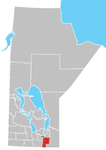
Place in Manitoba, Canada
| La Rochelle | |
|---|---|
 | |
| Coordinates: 49°21′20″N 96°58′48″W / 49.35556°N 96.98000°W / 49.35556; -96.98000 | |
| Country | |
| Province | |
| Region | Eastman |
| Census Division | No. 2 |
| Government | |
| • Governing Body | Rural Municipality of De Salaberry Council |
| • MP | Ted Falk |
| • MLA | Konrad Narth |
| Time zone | UTC−6 (CST) |
| • Summer (DST) | UTC−5 (CDT) |
| Area code(s) | 204, 431 |
| NTS Map | 062H07 |
| GNBC Code | GAOFK |
La Rochelle is a locality within the Rural Municipality of De Salaberry in south-eastern Manitoba, Canada. It is located approximately 60 kilometers (37 miles) south of Winnipeg. Established by Métis families in 1859, La Rochelle is the oldest community of the Rural Municipality of De Salaberry.
La Rochelle was the site of a small prisoner-of-war camp that held German soldiers captured during World War II. The camp was located just north of the intersection of Highway 59 and 23. It was a work camp that provided labour for working in sugar beets fields.
References
- "Geographical Names of Canada - Querying Distances". nrcan.gc.ca. October 24, 2011. Archived from the original on April 16, 2014. Retrieved February 16, 2013.
- "The Rural Municipality of De Salaberry - Our Municipality - RM Communities - La Rochelle". www.rmdesalaberry.mb.ca. 2011. Retrieved February 17, 2013.
- "German POW Camp Near St Pierre". SteinbachOnline.com. July 10, 2010.
| Division No. 2, Manitoba (Steinbach Area) | |||
|---|---|---|---|
| Cities |  | ||
| Towns | |||
| Villages | |||
| Rural municipalities |
| ||
| First Nations | |||
| Indian reserves | |||
| Unincorporated communities | |||
This Manitoba location article is a stub. You can help Misplaced Pages by expanding it. |